username
X
password
register
for free!
help


Virgus Canyon (Upper) - via Rug Road, AZ

Guide 6 Triplogs  1 Topic
  5 of 5  
Fav
Wish
1
details
drive
no permit
forecast
map
stats
photos
triplogs
topic
location
22 6 1
Statistics
tap row or icons for details
Difficulty 2 of 5
Distance Round Trip 3.9 miles
Trailhead Elevation 4,519 feet
Elevation Gain -165 feet
Accumulated Gain 752 feet
Kokopelli Seeds 7.66
 Interest Off-Trail Hiking, Historic & Seasonal Creek
feature photo
Photos Viewed All MineFollowing
12  2014-11-26
Parsons Virgus Negro Henry
JuanJaimeiii
40  2014-11-26
Parsons Virgus Negro Henry
CannondaleKid
20  2009-05-17 Grasshopper
2  2009-05-17 ssk44
Author
author avatar Guides 16,843
Routes 17,472
Photos 24
Trips 1 map ( 6 miles )
Age 28 Male Gender
Location HAZ, TrailDEX
Associated Areas
list map done
Globe Region
Historical Weather
Trailhead Forecast
Expand Map
Preferred Mar, Nov, Apr, Oct
Sun  5:59am - 6:42pm
1 Route
 
1 Alternative


remove free decal offer

  
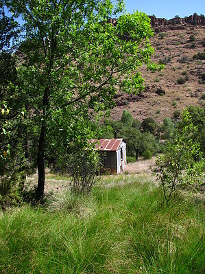
This lush, riparian, and remote canyon which the "Rug Road" crosses, offers a great location for a backpack campsite (only 1-mile hike from the TH Start location) and/or a remote off-trail canyon dayhike; This canyon has a seasonal creek with large sycamore trees, a historic cabin- Virgus Cabin & Corrals, and also has a perennial spring which is located only 100 yards behind the old Virgus Cabin;


2018-07-14 HAZ_Hikebot


    Check out the Triplogs.
    Leave No Trace and +Add a Triplog after your hike to support this local community.
    WARNING! Hiking and outdoor related sports can be dangerous. Be responsible and prepare for the trip. Study the area you are entering and plan accordingly. Dress for the current and unexpected weather changes. Take plenty of water. Never go alone. Make an itinerary with your plan(s), route(s), destination(s) and expected return time. Give your itinerary to trusted family and/or friends.

     Permit $$
    None


     Directions
    or
     Road
    Strictly 4x4

    To hike
    From the Phoenix area: TH Start for this hike and/or backpack begins 18 miles in from Mammoth, AZ, at the "primary campsite" location as described in HAZ hike description: "Rug Road-Mammoth to Klondyke to Hwy 70" (See this hike description and associated driving directions for all pertinent details);
    page created by Grasshopper on May 28 2009 7:04 pm
     90+° 8am - 6pm kills
    helpcorrectionissue

    end of page marker