 Route Editor

| Guide | ♦ | 5 Triplogs | 0 Topics |
details | drive | permit | forecast | route |
stats |
photos | triplogs | topics | location |
| 96 | 5 | 0 |
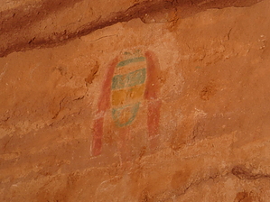
 Sheiks Canyon, one of the Grand Gulch tributaries, is located on Cedar Mesa. It's famous for the Basketmaker Green Mask pictograph, made with green, red, yellow and white pigments. The Mask is believed to be a rendering of a painted human scalp (very similar to an actual scalp found in a burial site in northeastern Arizona) and might serve as a warning to peoples passing by. A ranger shared that Shieks Canyon was named by ranchers that thought the mask looked like a sheik. The name stuck. Warning There are some seriously steep sections to this hike that might make some people uncomfortable. Scrambling is necessary over loose rock and dirt.
The hike starts out up on Cedar Mesa (no signage for the trailhead) and gradually drops down into Sheiks Canyon. Yellow House Ruin is located about a quarter of a mile into the hike. The site has three structures, with one having a rather yellow exterior and a nearly perfect, original ceiling. From here the hike continues downstream and it was advised to stay up on the right (looking down-canyon) and out of the boulder field as much as possible. There are numerous trails, so pick the one that feels right for you, all traveling in a westerly direction. You may see some granaries along the way. Or you may not because, at this point, you have to start paying attention and doing more route-finding. It would be helpful in numerous places to have a hiking buddy (or two) to scout ahead and give direction. Eventually you'll come to the junction with Grand Gulch. If you like, scramble up onto the sandstone to look into the lush Gulch and see The Thumb formation. You'll know it when you see it. Otherwise, take a left and skirt the base of what we called "The Submarine". Shortly after getting alongside the Sub, the canyon begins deepening and you'll have to make your way around VW-Beetle-sized boulders. Following the boulders is more route-finding down the sketchy slopes where, occasionally, it's best to do an upside-down crab crawl. Continue downstream and you'll eventually come to level ground again. Very shortly you'll notice a sandy beach on the right. Just after this is the alcove that holds the treasures that you've hiked for. There are several structures, including one with an interior wall that's been "wall-papered". It's not really wallpaper, but some very unusual decorating took place. The wall was painted black and over the black four mud spirals were fashioned. Strewn all along the ceiling and walls of the alcove were pictographs and petroglyphs. This is considered one of the most interesting and varied panels in Grand Gulch. And you may have to search a while for the Green Mask, but be patient and don't give up. You'll see pieces of pottery, an occasional corn cob, and there's an ammo can worth going through to learn more about the site. Return the way you came. Even though you'll be ascending to get out of the canyon, you won't likely spend as much time on the return as you'll spend far less time route-finding. Water Sources There was plenty of water after you reach Grand Gulch. Camping There are places to camp near the Green Mask site. Check out the Official Route and Triplogs. Leave No Trace and +Add a Triplog after your hike to support this local community. One-Way Notice This hike is listed as One-Way. When hiking several trails on a single "hike", log it with a generic name that describes the hike. Then link the trails traveled, check out the example. | |||||||||||||||||||||||||||||||||||||||||||||||||||||||||||||||||||||||||||||||||||||


