Route Editor

| Guide | ♦ | 2 Triplogs | 0 Topics |
details | drive | permit | forecast | route |
stats |
photos | triplogs | topics | location |
| 6 | 2 | 0 |
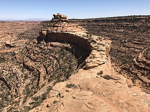
Sky Harbor by AZLOT69  This is a pleasant hike along the canyon rim with little elevation change until the prize at the final approach to the Citadel. The trail comes to a downslope of slickrock. Keep a watch out for cairns marking a down climb on the right. This involves some scrambling. There is a minor arch on the left as you continue to down climb following the cairns. It can be a little unnerving if you are afraid of heights. You can now see the narrow stone causeway with the rock island in the distance.
Check out the Official Route and Triplogs. Leave No Trace and +Add a Triplog after your hike to support this local community. | |||||||||||||||||||||||||||||||||||||||||||||||||||||||||||||||||||||||||||||||||||||||||||