Route Editor

| Guide | ♦ | 29 Triplogs | 0 Topics |
details | drive | no permit | forecast | 🔥 route |
stats |
photos | triplogs | topics | location |
| 327 | 29 | 0 |
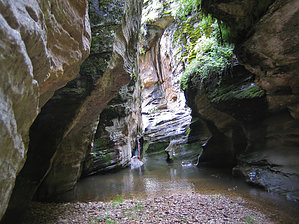
Canyons are inherently risky. Flash floods occur without notice on sunny days. Technical skills & surrounding topography knowledge required yet does not eliminate risk.
Fun tributary to West Clear Creek by toddak   Overview OverviewClover Creek Canyon is a challenging but non-technical canyon following one of the headwaters tributaries of West Clear Creek. Warning Some canyon sections are tight and narrow and could be dangerous in heavy monsoon downpours.
From the parking lot, go through the cattle fence and follow the creek along an old dirt road until you reach an old stone and cement bridge. Leave the road, going left and following the creek; shortly, you will contact a barbed-wire fence with a sign designating the West Clear Creek Wilderness. Directly across the creek is a huge rock overhang that makes a fabulous shelter in the rain. The stream gently wanders through natural, open terrain for the next mile or so, often following faint trails, passing several sweet camping sites. Eventually, the canyon starts to narrow - the next 3 miles are the tightest section, with some scrambling and working around boulders and fallen trees. Somewhere around the 2.5-mile point is the most significant obstacle on the hike, a division of smooth rock sloping down to a 5 - 6 foot downclimb into a waist-deep pool. Easy to negotiate to go downstream, it would be a bit more complicated if returning upstream, although we were able to use a log in the slot to make it easier. The creek turns sharply left at about the 4-mile mark as it joins another side canyon coming in from the northeast. The next mile or so downstream is open and relaxed, walking through grassy meadows and forest to the junction with Tom's Creek coming in from the southwest. Go right (downstream) at the intersection of the two creeks for roughly 3 miles of moderate hiking and pleasant wading to the junction with Willow Valley and the true start of West Clear Creek. From here, you can return upstream 8 miles to the start. Better is to continue down WCC several hundred yards to where the Maxwell Trail will take you steeply back up to the rim on the north side of WCC canyon. There you can meet a shuttle vehicle to take you back around to the start via 9 miles of dirt on Forest roads 81E and 81 north to Lake Mary Road and then south 13 miles on pavement back to Milepost 285 on Hwy 87. Check out the Official Route and Triplogs. Leave No Trace and +Add a Triplog after your canyon trip to support this local community. | ||||||||||||||||||||||||||||||||||||||||||||||||||||||||||||||||||||||||||||||||||||||||||||||||||||||||||||||||||||||||||||||||||||||||||||||||||||||||||||||||||||||||||||||||||||||||||||||||||||||||||||||||