Route Editor

| Guide | ♦ | 2 Triplogs | 0 Topics |
details | drive | no permit | forecast | map |
stats |
photos | triplogs | topics | location |
| 26 | 2 | 0 |
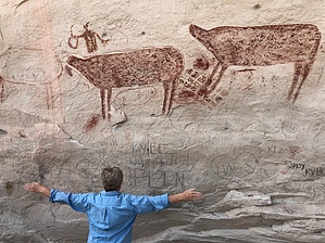
Somewhere In Time by AZLOT69 The first Caucasians were documented to come thru and settled this area in about 1870. Prior to that time those that lived here displayed their art on these walls. Since 1870, the Caucasians joined in the art fest with inscriptions, cowboy art and just plain vandalism.
The hike in is on a very sandy trail. The blowing sand has completely filled the cave. The first thing that catches your eyes is the very large red pictograms of headless Elk. When I say large I mean large. The Elk without there heads and racks are four to six feet long each. Look closely and they spattered some of the red dye used to show blood from the drying animals dripping. There are also human figured that seem to be wearing headdress made of the Elks head complete with the rack. The site unfortunately has been picked over for over a hundred years. Closer examination shows many other pictograms and petroglyphs of various age. The inscriptions are interesting as well. It was not hard to find sharpening stones and points throughout the area. The trail continues to a waterfall which happened to be dry the day we visited. When finished return the way you came. Check out the Triplogs. Leave No Trace and +Add a Triplog after your hike to support this local community. | |||||||||||||||||||||||||||||||||||||||||||||||||||||||||||||||||||||||||||||||||||||||||||||||||