|
tap row or icons for details
|
| Difficulty |
|
1.5 of 5 |
| Route Finding |
|
3 of 5 |
| Distance Loop |
|
1.6 miles |
| Trailhead Elevation |
|
4,965 feet |
| Elevation Gain |
|
166 feet |
| Accumulated Gain |
|
340 feet |
| Avg Time Round Trip |
|
1 hour |
| Kokopelli Seeds |
|
3.3 |
| | Backpack Possible - Not Popular | | unreported if dogs are allowed
editedit > ops > dogs to adjust |
| | |
|
|
15 |
2023-11-25 |
|
|
|
6 |
2018-04-30 | AZLOT69 |
|
| |
|
|
|
list |
map |
done |
Central Region |
| | |
|
| |
|
|
Historical Weather |
| Trailhead Forecast | | |
|
 |
|
|
| Preferred Oct, Apr, May, Mar → 9 AM |
| |
|
|
| | |
| |
Named Locations Coordinate Links
| |
|
| help future hikers |
| post a gps route now |
|
Goblin Valley
|
5.38 mi
655 ft |
 |
| | |
| |
|
|
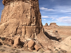
  Goblin Valley State Park makes a great base camp for anyone visiting the San Rafael Swell southern section of Utah. There are several places in the area to boondock but it's kind of nice to have showers and water readily available at the end of each days adventures. The Goblin Valley reminds me of Bryce canyon on a smaller scale. The wind, sand, rain shaping the sandstone into other worldly shapes and figures. There are a couple short trails in the park or you can just wander around. Carmel Trail starts from a vista point in the northeast side of the day parking lot. Other than the sign starting Carmel Trailhead, there is no signage as to where to go and the hardpacked ground gives no clue which way to go. Head east stating high on the bench. You will come to a trail marker showing where to descend to the floor of the valley. The trail becomes somewhat more visible at this point. Watch for additional markers. You will come to a Y of washes. A sign here directs you to the left. It's a little disorienting what direction you are going as you are down in a wash meandering. Eventually you will come to a sign directing you yet again into a wash entering from the left. The trail gets interesting now as out narrows to a slot canyon. A couple of scrambles and you will be back to the parking lot.
A great short family hike or great warm up if you arrived too late in the day to adventure into the San Rafael Swell. |
 Route Editor