 Route Editor

| Guide | ♦ | 1 Triplog | 0 Topics |
details | drive | no permit | forecast | map |
stats |
photos | triplog | topics | location |
| 9 | 1 | 0 |
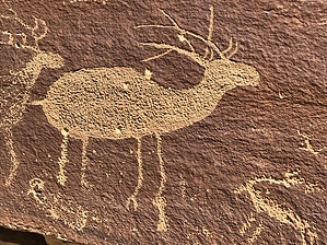
Cultures Collide by AZLOT69  At 15.9 miles the is one of many dirt roads with access to the river on your left. Look right, there is a huge boulder with large human Petroglyphs. At 17.8 you will find another panel of large Elk Petroglyphs on the right. This is directly across from a rock that looks like "Nefertiti". It does not make much sense at this point. You have to continue a few hundred yards and while looking for another set of small Petroglyphs on the right look back south on the west side of the Green River and view "Nefertiti". There is a boat launch here and this is the end of the road. There is a rock structure here resembling an Indian ruin. Hard to say whether it is or some industrious campers built a wind block. This is the trailhead.
The hike follows on the shore of the Green River sometimes overgrown with vegetation. Its easy to follow and you will find yourself looking for other signs from the past. The trail turns east as it enters Rattlesnake Canyon. At this point return the way you came or continue on. Check out the Triplog. Leave No Trace and +Add a Triplog after your hike to support this local community. One-Way Notice This hike is listed as One-Way. When hiking several trails on a single "hike", log it with a generic name that describes the hike. Then link the trails traveled, check out the example. | ||||||||||||||||||||||||||||||||||||||||||||||||||||||||||||||||||||||||||||||||


