Route Editor

| Guide | ♦ | 2 Triplogs | 0 Topics |
details | drive | no permit | forecast | route |
stats |
photos | triplogs | topics | location |
| 10 | 2 | 0 |
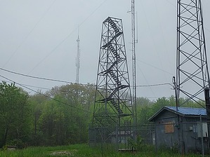
black as coal by DixieFlyer  Black Mountain is the highpoint of the Commonwealth of Kentucky. It is at an elevation of 4,139 feet and it has a prominence of 1,899 feet. Black Mountain is in Harlan County, the epicenter of Appalachian coal mining, and is a short distance from the Kentucky-Virginia border. Hike From the trailhead, the summit is about 1,000 feet away. To get there, you'll hike on a dirt jeep-type road that angles off to the left from the trailhead. You'll be able to see the fire tower at the summit from the trailhead.
Synopsis This hike is mainly of interest to those trying to bag state highpoints. However, if for some reason you happen to find yourself on Highway 160 at the Virginia-Kentucky state line, you may as well spend a few minutes doing this hike. Check out the Official Route and Triplogs. Leave No Trace and +Add a Triplog after your hike to support this local community. | |||||||||||||||||||||||||||||||||||||||||||||||||||||||||||||||||||||||||||||||||||||