|
tap row or icons for details
|
| Difficulty |
|
3 of 5 |
| Route Finding |
|
1 of 5 |
| Distance One Way |
|
3.5 miles |
| Trailhead Elevation |
|
5,520 feet |
| Elevation Gain |
|
1,660 feet |
| Avg Time One Way |
|
2.5 hours |
| Kokopelli Seeds |
|
9.03 |
| Interest Ruins, Historic, Seasonal Waterfall, Seasonal Creek & Perennial Creek | | Backpack Yes & Connecting | |
| | |
|
|
|
list |
map |
done |
Reno Region |
| | |
|
| |
|
|
Historical Weather |
| Trailhead Forecast | | |
|
 |
|
|
| Preferred May, Oct, Sep, Jun → 8 AM |
|
|
|
Seasons Early Spring to Late Autumn |
|
|
| | |
| |
Named Locations Coordinate Links
| |
|
| Lakeview-Sawmill Canyon
|
3.52 mi
1,660 ft |
|
|
| | |
| |
|
|
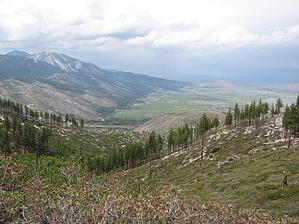
 History: History: In 1859 the discovery of gold and silver in nearby Virginia City created many millionaires. Some of those fortunes were made not by gold or silver but by supplying the mines with commodities such as timber and water. As the mines of Virginia City quickly depleted the supply of timber and water locally the population looked west to the seemingly inexhaustible supply of water and timber in the Sierra Mountains twelve miles to the west. The tremendous fortunes to be made here attracted experts who applied their ingenuity. The instability of the Comstock geography required a new system of square setting timber in the deep shafts, a new deep mining technique that spread across the world. This required mass quantities of lumber. The mines also required a never ending supply of water. Because the Sierra are taller than the Virginia Mountains engineers designed an inverted siphon pipe line capable of carrying 2,200,000 gallons of water every twenty four hours. The pipeline brought the water two thousand feet down from the Sierra mountains passing through Washoe Valley then up the Virginia Mountains to Virginia City powered only by gravity. The flumes which brought the water to the pipeline shared flumes bringing timber from the Sierra to sawmills, with all this commodity headed for Virginia City. Overview: Ascending the Sierra from the east generally involves an aggressive rise in elevation and this hike is no exception to that rule. Expect a steep grade combined with awesome views. Visiting remnants of the original pipeline, flumes and sawmill are some of the highlights of this trip. Hike: Getting right down to business, the trail starts its climb right from the beginning. A heavy cover of pine trees makes for great cover and shade. Huge pine cones and a thick carpet of needles make for a cushioned trail which is easy to follow. A couple of switchbacks brings you quickly up to a nice view of Washoe Lake and Washoe Valley, named after its original inhabitants, the Washoe Indians. At the entrance to Sawmill Canyon the trail makes a sharp left and now follows the creek. The creek crosses under the trail through culverts a couple of times. In the spring the water runoff is substantial and quick flowing. With the sharp grade of the trail its surprising to have such a substantial flow of water. While there is no relief in the ascent use the scenery as an excuse to stop and catch your breath. The towering Sierras accented by Slide Mountain to the north and ever increasing panoramic views of Washoe Lake to the east. An overlook at the two mile point offers views of Carson City, the capital of Nevada to the south and the Virginia Mountains to the east. The pine trees appear to be at a forty five degree angle to the mountain as they stand straight up. At two and three quarter miles you have gained about 1400 feet of elevation. Named the tanks, you have arrived at a key water source for Carson City.
The present day water tank here at ground level is at precisely the same spot as the pipeline started towards Virginia City in 1876. With a little exploring around you can find the original pipeline and structures supporting it in the immediate vicinity. The trail levels off now following the original flume. Over the next mile you will not notice and only gain about two hundred feet in elevation. The trail is flat and smooth which makes gawking at the views very enjoyable and worth the climb to get here. Arriving at a T intersection, stop here and explore the surrounding area. This is the original location of the Sierra Nevada Wood and Lumber Company and if you look around you can find artifacts which of course should be left where you find them. Bricks, domestic debris, glass, saw blades and industrial tools remain as well as a steam boiler. As you look around at the tremendous trees that have re-grown, imagine this area completely clear cut by the industrious but not environmentally minded people of the 1880s. When finished return the way you came. The trip back will be more enjoyable with a walking stick(s) and if you have ill fitting shoes you will certainly know it at the end of the day. Time cited is one way. One-Way NoticeThis hike is listed as One-Way. When hiking several trails on a single "hike", log it with a generic name that describes the hike. Then link the trails traveled, check out the example. |
 Route Editor


