username
X
password
register
for free!
help
 This is likely a great time to hike this trail!  Check out "Preferred" months below, keep in mind this is an estimate. 
  

Mount Rogers Loop from Massie Gap, VA

Guide 2 Triplogs  0 Topics
  4 of 5  
Fav
Wish
0
details
drive
permit
forecast
route  
stats
photos
triplogs
topics
location
30 2 0
Statistics
tap row or icons for details
Difficulty 4 of 5
Route Finding 1 of 5
Distance Lasso-Loop 14.65 miles
Trailhead Elevation 4,751 feet
Elevation Gain 1,060 feet
Accumulated Gain 3,010 feet
Avg Time Round Trip 6
Kokopelli Seeds 29.7
 Interest Historic, Perennial Creek & Peak
 Backpack Yes & Connecting
unreported if dogs are allowed
editedit > ops > dogs to adjust
feature photo
Photos Viewed All MineFollowing
Will recalculate on button tap!
27  2022-07-16
Mount Rogers - Virginia Highpoint
DixieFlyer
9  2019-06-01 caragruey
21  2018-06-03 caragruey
Author
author avatar Guides 4
Routes 52
Photos 1,303
Trips 75 map ( 426 miles )
Age Female Gender
Location Sun City
Associated Areas
list map done
Western Region
Historical Weather
Trailhead Forecast
Radar Map
Expand Map
Preferred Jul, Aug, Jun, Sep
Sun  6:00am - 6:49pm
Official Route
 
1 Alternative


hemlock, peaks & ponies
by caragruey

 Likely In-Season! 
Start at the Massie Gap Trailhead and head clockwise on the Appalachian Trail up to Wilburn Ridge. Wilburn Ridge Trail joins the AT up to Mount Rogers Spur Trail #4590. There is a shelter along the Spur Trail, with a loft. Several Privy stations along the trail too. Bag the summit. The first large rock on the summit has the USGS medallion and just across from it another identical medallion.


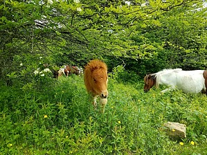
Back down the Spur Trail to the Crest Trail. Take the Crest Trail to loop. Cross over the Scales Trail and rejoin up with the AT. Trails divide and wind around through this area with undulating terrain. Ponies are everywhere in small groups as well as Long Horn Cattle. There are many camping areas and campers.
remove free decal offer
Other loop variations are possible with Pine Mountain Trail, Scales Trail, Virginia Highlands Horse Trail and Bearpen Trail.

2018-06-04 caragruey


    Check out the Official Route and Triplogs.

    Note
    This is a moderately difficult hike.
    Leave No Trace and +Add a Triplog after your hike to support this local community.
    WARNING! Hiking and outdoor related sports can be dangerous. Be responsible and prepare for the trip. Study the area you are entering and plan accordingly. Dress for the current and unexpected weather changes. Take plenty of water. Never go alone. Make an itinerary with your plan(s), route(s), destination(s) and expected return time. Give your itinerary to trusted family and/or friends.


     Directions
    or
     Road
    Paved - Car Okay

    To Massie Gap Trailhead
    From Abingdon, take 58 East until you reach Grayson Highlands State Park on the left through SR 362. Continue three miles to Massie Gap parking.
    page created by caragruey on Jun 04 2018 7:37 pm
     90+° 8am - 6pm kills
    helpcorrectionissue

    end of page marker