Route Editor

| Guide | ♦ | 15 Triplogs | 0 Topics |
details | drive | no permit | forecast | 🔥 route |
stats |
photos | triplogs | topics | location |
| 147 | 15 | 0 |
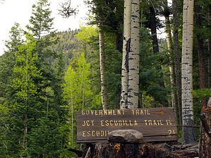
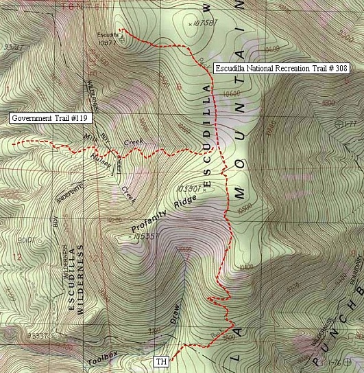
get high, courtesy of the government by PrestonSands  Overview OverviewThe Government Trail #119 offers hikers an alternative and more aggressive route to the heights of Escudilla Mountain. It allows for a loop hike using the Escudilla Trail #308 (a.k.a; the Escudilla National Recreation Trail) and Forest Road #8056. This hike delivers outstanding views from Arizona's highest fire lookout on one of the state's highest mountains. Distance listed in the statistics is for a round trip hike to the Escudilla lookout tower and return. The actual length of the Government Trail, though, is around 2.9 miles one way. Warning Start early to avoid lightning during monsoon season!
The unsigned Government Trail begins at a gated entrance to a wildlife habitat area, 2.6 miles up Forest Road 8056 from U.S. Highway 191. The Government Trail leaves this informal trailhead (33.93026 N, 109.14743 W) following an old closed road route. Alternating between heading east and north, the trail gradually gains elevation in a peaceful ponderosa pine forest. At 0.5 miles, occasional blue diamonds nailed to trees begin to mark the route as the trail turns north. Then, just after crossing the marshy course of Hulsey Creek at 0.8 miles, the road curves east to ascend a long, ramp-like ridge. This stretch of the Government Trail, still on a closed road, is characterized by open stands of tall trees, which allow for sporadic views of the Escudilla lookout tower, and Profanity Ridge. The one-and-a-half mile point brings the Government Trail to a small, ridge-top meadow at 9220 feet, where the old road forks (33.93855 N, 109.1308 W). Go uphill (right) past a large cairn. The trail becomes noticeably steeper, and the old road increasingly vague as the hike enters lush coniferous forest along the upper reaches of Hulsey Creek. At 2 miles, the ancient road makes a sudden swing to the left (north), where it encounters the Escudilla Wilderness boundary and a decrepit sign for the Government Trail (33.9363 N, 109.1231 W). At this point, the Government Trail leaves the old roads behind, turns east, and resumes its relentless climb up the north side of Profanity Ridge, via a long series of switchbacks shaded by moss-covered stands of Engelmann Spruce. Just above the 10,200-foot contour, the trees part momentarily to reveal a talus slide at the head of Milk Creek. From this jumbled stack of basalt boulders, one can enjoy a rare view to the west of the White Mountains. Above the talus slide, the ascent begins to ease, and the Government Trail enters a large sloping meadow at 10,400 feet. The trail disappears in the grass, but a trail signpost soon comes into view, marking the junction with the Escudilla Trail at about 2.9 miles (33.9387 N, 109.11188 W). At this point, you will likely want to continue to the fire lookout, which lies a little over a mile up the Escudilla Trail. Turning north onto the Escudilla Trail, the climb continues as the trail crosses the expansive mountain top meadow, once again following the route of a closed road. The trail soon reenters spruce forest and begins to curve west at 10,700 feet. The Escudilla Trail makes a short dip and then a brief, final climb before reaching its end at the lookout tower and unofficial summit at 10,877 feet. I say "unofficial", as the true summit, at 10,912 feet, is a little over a half-mile to the north. One can enjoy great views from the end of the trail or, for a spectacular 360-degree view, climb the fire tower. One can see much of eastern Arizona and western New Mexico from this incredible mountain. Return the way you came, or take the Escudilla Trail and Forest Road #8056 back to your starting point for an approximately 9.3-mile loop. Gate Policy: If a gate is closed upon arrival, leave it closed after you go through. If it is open, leave it open. Leaving a closed gate open may put cattle in danger. Closing an open gate may cut them off from water. Please be respectful, leave gates as found. The exception is signage on the gate directing you otherwise.
Check out the Official Route and Triplogs. Leave No Trace and +Add a Triplog after your hike to support this local community. | ||||||||||||||||||||||||||||||||||||||||||||||||||||||||||||||||||||||||||||||||||||||||||||||||||||||||||||||||||||||||||||||||||||||||||||||||||||||||||||||||||||||||||||||||||||||||||||||||||||||