 Route Editor

| Guide | ♦ | 4 Triplogs | 0 Topics |
details | drive | no permit | forecast | 🔥 route |
stats |
photos | triplogs | topics | location |
| 72 | 4 | 0 |
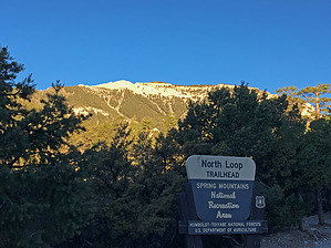
rugged, broken terrain by toddak Current Official Route for east is a guess by HAZ_Hikebot. Should suffice with the fine details below for the end for avid off trail explorers. Overview Fun hike and scramble to the second highest peak in the Spring Mountains at 11,528'. The peak can be climbed from the east or west sides. After leaving the maintained trails, the routes follow fairly well-established "unofficial" use trails with some steep, loose sections and occasional moderate scrambling (class 2/3).
From the North Loop trailhead, hike up about 3 miles to the Mummy Springs junction at the 3000 year old "Raintree" bristlecone pine and go right a half mile to Mummy Springs where the use trail starts. The use trail switchbacks steeply up the slope above the springs to a rocky ridgeline. Keeping the steep cliffs on your left, contour north along the base of the wall for about a third of a mile. You'll pass one narrow gully, then arrive at a larger second gully leading steeply up towards the summit. Scramble up this chute and just before reaching the top, follow the route up and right to escape the chute through a notch. Again there will be steep cliffs on your left, continue north until you can go up and left and then back around to the summit. West approach Hike up the Trail Canyon trail to the junction with North Loop, go left and continue past Cave Spring another half mile. Just past where the trail makes a sharp switchback to the west at about 10,400', look for a large dead tree with a carved "M" and an arrow pointing to a use trail that heads up a dirt scree slope to a rocky ridgeline. Ascend the slope and continue up the rocky ridgeline towards the peak to the base of a cliff band. Follow the use trail north along the base of the cliff and then up through a large notch and onto the summit plateau. While the summit gets lots of visitors, it should be noted that Mummy Mountain is rugged, broken terrain with the potential for danger if you get off route. Check out the Official Route and Triplogs. Leave No Trace and +Add a Triplog after your hike to support this local community. One-Way Notice This hike is listed as One-Way. When hiking several trails on a single "hike", log it with a generic name that describes the hike. Then link the trails traveled, check out the example. | ||||||||||||||||||||||||||||||||||||||||||||||||||||||||||||||||||||||||||||||||||||||||||||


