username
X
password
register
for free!
help
 This is likely a great time to hike this trail!  Check out "Preferred" months below, keep in mind this is an estimate.
 

Gunnison between North Fork and Smith River, CO

Guide 1 Triplog  0 Topics
  0 of 5  
Fav
Wish
0
CO > West
details
drive
no permit
forecast
route  
stats
photos
triplog
topics
location
6 1 0
Statistics
tap row or icons for details
Trailhead Elevation 5,111 feet
feature photo
Photos Viewed All MineFollowing
6  2018-06-19 Steph_and_Blake
Author
author avatar Guides 100
Routes 63
Photos 2,548
Trips 184 map ( 820 miles )
Age 76 Male Gender
Location Grand Junction, CO
Historical Weather
Trailhead Forecast
Radar Map
Expand Map
Preferred May, Oct, Sep, Apr
Sun  5:46am - 6:33pm
Official Route
 
0 Alternative


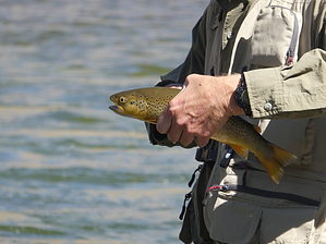
wade across the water... water
by Steph_and_Blake

 Likely In-Season!
This Description is meant to serve as a guide for gaining wading access to the portion of the east bank of the Gunnison River, between the North Fork and the Smith River. In no way is it meant to be used as a fishing guide. However German Browns and Rainbows are aplenty!


After turning off US-92 at the signed Pleasure Park, follow the road nearly to the river. At the first sign (with a map of the rivers) take a left. The commercial lodge will be behind you. In a very short distance you will come to a parking area on your right. Park here.
remove free decal offer
Gather all your gear and head towards the picnic tables. Before reaching the tables you’ll see a path on your left. Take this to the North Fork. Wade across the North Fork and pick up a trail headed to your right (headed southwest) to the Gunnison. Once at the Gunnison, continue along the trail on the east side of the river. There are two trails, actually - an "upper" and a "lower" (at riverside) with several short connectors sprinkled along the way. Happy fishing!

Warning
There is occasional poison ivy along the trail, but it can be avoided. There are also some steep descents from the upper trail down to the river over loose terrain, so take it slow and don’t wear your Corkers. The fish will wait for you to get there safely.

2018-06-23 Steph_and_Blake


    Check out the Official Route and Triplog.
    Leave No Trace and +Add a Triplog after your fly fishing to support this local community.
    WARNING! Hiking and outdoor related sports can be dangerous. Be responsible and prepare for the trip. Study the area you are entering and plan accordingly. Dress for the current and unexpected weather changes. Take plenty of water. Never go alone. Make an itinerary with your plan(s), route(s), destination(s) and expected return time. Give your itinerary to trusted family and/or friends.

     Permit $$
    None


     Directions
    or
     Road
    FR / Dirt Road / Gravel - Car Okay

    To fly fishing
    From Delta, CO, drive west on US-92 for 14.3 miles. Turn right onto Pleasure Park Road. Take the road to the end.
    page created by Steph_and_Blake on Jun 23 2018 5:08 pm
     90+° 8am - 6pm kills
    helpcorrectionissue

    end of page marker