Route Editor

| Guide | ♦ | 1 Triplog | 0 Topics |
details | drive | no permit | forecast | route |
stats |
photos | triplog | topics | location |
| 9 | 1 | 0 |
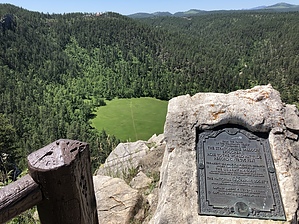
Out Of This World by AZLOT69 Few connect South Dakota with aeronautical successes in the last 100 plus years. The Wright Brothers, John Glenn orbiting the earth, Neil Armstrong walking on the moon come to mind. In 1934 the Army Air Corp and the National Geographic Society picked a relatively unknown location called Moonlight Valley outside Rapid City, South Dakota to launch a Hot Air Balloon in the hopes of reaching the Stratosphere. Three Army officers in the largest Hot Air Balloon ever constructed embarked into the unknown, more than twenty years before the Soviet Union flew Sputnik. The first attempt failed with the officers parachuting to safety. The feat was attempted again in 1935 before an audience of 50,000 people. It was successful in setting an official altitude of over 74,000 feet. The Valley was renamed Stratobowl and has a Hot Air Balloon weekend annually to commemorate the event.
The hike is Straight forward on an old forest road. Forest Road 370 is barricaded, so go around the barricade and hike up the gravel road that nature is reclaiming. The trail meanders thru mature forest and soon you realize you are on the rim of this spectacular valley shaped like a bowl. Several side trails take you to viewpoints of the valley below which include Spring Creek. The launch site is well maintained and has a peace sign mowed into it like crop circle art. There is a formal deck with plaque for viewing as well as several granite tablets documenting the accomplishments at this location. Check out the Official Route and Triplog. Leave No Trace and +Add a Triplog after your hike to support this local community. | ||||||||||||||||||||||||||||||||||||||||||||||||||||||||||||||||||||||||||||||||||||||||||||