 Route Editor

| Guide | ♦ | 8 Triplogs | 0 Topics |
details | drive | no permit | forecast | route |
stats |
photos | triplogs | topics | location |
| 96 | 8 | 0 |
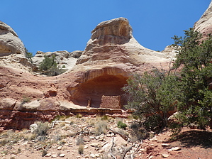
visit the ancestral hood by Steph_and_Blake This is a moderate hike past nine ancient homesites in Sand Canyon. Recommendation It would be a good idea to visit the Canyons of the Ancients Visitor Center in Delores before making this hike. The friendly folks there have a newspaper that contains pictures and a description of the various ruins that would be helpful for your hike.
There is no water along the way and only meager shade is offered by the juniper and pinon pines in the last 6 miles. Also, this trail is open to mountain biking and horse-riding. However, the upper 2 miles of switchbacks and exposed, steep grades would be very challenging (if not impossible) on a bike or horse. Lastly, camping is not allowed in Sand Canyon. Hike From the parking area, the trail is readily seen as it proceeds into the woods, headed in a southerly direction. After a very brief flat section, you scramble down into the head of Sand Canyon. The first 1.3 miles is easy cruising among trees that provide pleasant shade. Once through the "easy cruising" section, you'll pop out at the point to where you'll make a much more serious descent into Sand Canyon. Take a moment to enjoy the views and admire the various colors of the canyon before you. On foot, the drop into the canyon isn't that difficult or sketchy. There are a few patches, though, where the trail is loose and you'll want to take extra care. And there are a couple sections right before you get to the canyon floor where you might use a tree branch or root to help you stay upright. You might wonder if the ancient peoples used this same trail to get from Sand Canyon Pueblo (located where you parked your car) down to the cliff dwellings in the side canyons before you. From the bottom of the canyon, you'll continue to head south, eventually making your way up onto a bench "one layer up" on the right. This is when things get interesting! The cliff dwellings are all located in side canyons, generally on your right and, for the most part, facing south. The BLM has noted the location of the ruins with either a large cairn and/or a brown "Spur" sign. Taking each of the spurs makes the 6.5 mile hike into one closer to 8 miles. Oddly, we saw no rock writings on the hike. Oh, and be sure to keep your binos out to periodically scan across the canyon to locate ruins to the east. Near the end of the hike you'll descend again to join up with McElmo Canyon. Return the way you came or organize a shuttle.
Check out the Official Route and Triplogs. Leave No Trace and +Add a Triplog after your hike to support this local community. One-Way Notice This hike is listed as One-Way. When hiking several trails on a single "hike", log it with a generic name that describes the hike. Then link the trails traveled, check out the example. | ||||||||||||||||||||||||||||||||||||||||||||||||||||||||||||||||||||||||||||||||||||||||


