Route Editor

| Guide | ♦ | 3 Triplogs | 0 Topics |
details | drive | no permit | forecast | route |
stats |
photos | triplogs | topics | location |
| 12 | 3 | 0 |
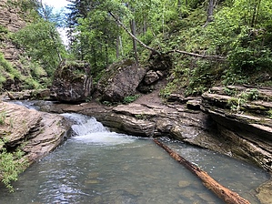
You're Gonna Get Wet by AZLOT69 Warning People underestimate this hike and while it is definitely a family hike, it has its danger aspects. Many have been seen returning with sprains and abrasions. Access The trailhead itself is the first concern. It is surrounded by private property. There is little parking and parking is not allowed on the highway in the immediate area. Just a football fields distance south on the highway is a nice pullout accommodating several vehicles and its just a short hike anyhow.
Going back to Cleopatra hike over the bridge which is Spearfish Creek. The hike starts directly in front of you as the road curves left. In the past there was no sign here but as of this writing there is a temporary sign marking the trail due to so many people getting lost. On your right is a creek that flows into spearfish creek. This smaller tributary has several names, Cleopatra Creek, Cole Creek and Squaw Creek. The object of this hike is to follow Squaw Creek up stream to Devils Bathtub. Thick, mature forest lines the trail. This will involve at least eight creek crossings to avoid obstacles along the way. The creek crossings are very rocky, water 1 to 2 feet deep and some have strong current. Lets not forget most of those rocks are unstable or covered with slippery moss. Supportive water shoes are recommended as well as a hiking stick. The crossings are pretty clear but there are many paths to choose from. Some crossings are more conservative, some are risky. As long as you have the creek in site your OK. The further in the taller the rock walls become offering nice scenery. The first pool you come to is known as the kiddie pool. Fairly calm, shallow water here. From here the hike continues on the left rock face wall. This involves some minor scrambling which may freak out some. The creek gathers some momentum here as it compresses thru the rocks. The second pool is much deeper and some people slide the creek into it. Strong current here and no idea how deep it is. Danger jumping into the unknown. More scrambling upstream to the third pool, Devils bathtub. It has a resort feel to it. Very relaxing, no doubt you'll want to spend some time here. When you have your fill, return the way you came. Where does the name Devils Bathtub come from ? The area is thick with poison ivy and Indian Lore has it that poison ivy oil was in the water and caused a rash to those who bathed here. Check out the Official Route and Triplogs. Leave No Trace and +Add a Triplog after your hike to support this local community. | |||||||||||||||||||||||||||||||||||||||||||||||||||||||||||||||||||||||||||||||||||||||||