Route Editor

| Guide | ♦ | 2 Triplogs | 0 Topics |
details | drive | no permit | forecast | route |
stats |
photos | triplogs | topics | location |
| 22 | 2 | 0 |
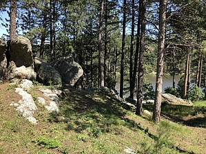
Hang Em High by AZLOT69 The name speaks for itself. Horsethief trail is named after a gang from the late 1800's who used it as an escape route. The lake came much later. As the work on Mt Rushmore progressed in the 1930's, the vision was to make the area a destination for families. One such idea was to build lakes in the area. Horsethief was constructed by the CCC in the 1930's by placing a dam on Pine Creek. The lake and adjoining campground is the closest facility to Mt Rushmore, less tan two miles away. Hike The hike starts in the day use area of Horsethief Lake. The trail head is easy to pass by. When pulling in the gravel drive just as the gravel turns to asphalt there is room for 4-5 cars in the gravel on your left. There is a kiosk here and a no cost wilderness permit must be completed. Take a photo of the map for reference and start up the Horse Thief Trail #14. You won't see the lake again for 5.25 miles. The trail climbs for the first mile thru thick mature forest with granite monoliths all around. Soon you enter the Black Elk Wilderness. Pine Creek flows alongside the trail, a babbling brook with an occasional waterfall. The hike involves multiple creek crossings but absent a slip you shouldn't get wet. You will come to a T in the trail. Horsethief continues straight but you want to turn right on Centennial Trail #89. The trail continues with a series of switchbacks to the high point of this adventure. The trail is overgrown thru this section but easy to follow. Centennial #89 comes to a T with trail #5 going to the left, you want to go right here staying with # 89 headed to the Big Pine trail head. The trail breaks free of the thick forest at this point. Soon you will hear the sound of traffic and arrive at highway 244. A short hike of a quarter mile to the right alongside the highway will bring you back to Horsethief Lake. Take the trail alongside the lake back to your vehicle. You may want to take a dip in the lake while there. Check out the Official Route and Triplogs. Leave No Trace and +Add a Triplog after your hike to support this local community. | ||||||||||||||||||||||||||||||||||||||||||||||||||||||||||||||||||||||||||||||||||||||||||||||||