Follow Twenty-Two Creek the entire way, climbing continuously, but not steeply, through old-growth timber and a large talus slope. The trail is used year-round and is always very crowded on summer weekends. This is one of three Research Natural Areas on the district. It was set aside in 1947 to study the effects on water, wildlife and timber of an area left in its virgin state, as compared to similar areas under intensive management. A one-mile loop trail takes you around the lake. Please stay on the trail to protect rare plants and reduce erosion. The lake is in a glacier-carved basin on the north flank of Mt. Pilchuck. Fishing can sometimes be quite good as the lake is 53-feet deep.
@Harry writes
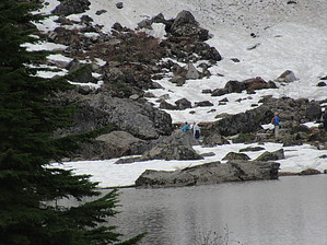
All forest trail next to or within earshot of Creek 22, the outflow of Lake 22. Steady elevation gain on a well-maintained trail of dirt with some roots and rocky stretches. Round trip to the lake is 5.4 miles. Loop around the lake of 1.1. miles is certainly optional as the lake itself is an awesome destination for a break, picnic, swimming, and photography. The first view at top of the trail is this awesome natural lake backed by Mount Pilchuck, its snow, glaciers, and waterfalls. The trail continues around the lake, left or right, on boardwalks before evolving into a natural trail, rocky trail, and maybe a snowy trail. Sturdy boots are recommended because of the various rocky areas and slippery areas on both the access and lake segments.
WARNING! Hiking and outdoor related sports can be dangerous. Be responsible and prepare for the trip. Study the area you are entering and plan accordingly. Dress for the current and unexpected weather changes. Take plenty of water. Never go alone. Make an itinerary with your plan(s), route(s), destination(s) and expected return time. Give your itinerary to trusted family and/or friends.
To hike Seattle is the closest (60 miles, ~2 hours) big city. Granite Falls is the closest town. Best to use GPS (trailhead is near 33515 Mountain Loop Highway, Granite Falls). There are multiple routes from Seattle and can be road construction on some. Basic directions from Seattle area are N on I-5, exit 194 US 2 East, and follow your GPS from there. The last part of the drive is on Mountain Loop Highway, interesting and enjoyable itself. And you will cross and drive next to the South Fork Stillaguamish River.
 Route Editor