Route Editor

| Guide | ♦ | 1 Triplog | 0 Topics |
details | drive | permit | forecast | map |
stats |
photos | triplog | topics | location |
| 12 | 1 | 0 |
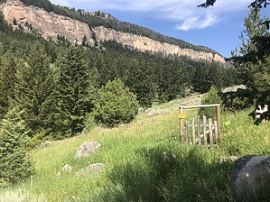
Go Climb A Rock by AZLOT69 The hike in starts by passing thru a gate with an electric fence. It's a well worn path but partially overgrown to start with. It's a very remote area teaming with wildlife. Bears, moose, elk, deer, to name a few. After a quarter mile you'll arrive at a gigantic boulder. A cow skull directs you left to Valhalla, right to French Cattle Ranch. The gigantic boulder is decorated with various skeleton parts. At the base of the boulder is a storage locker for the Washakie County Sheriff Search and Rescue. Going to the right here, the trail starts to climb and gets steeper and steeper. These climbers apparently don't believe in switchbacks, they are here to climb. The trail eventually makes a beeline to the cliffs that have been off to the left the entire time. The trail parallels the cliffs from here on. The routes are easily spotted with hardware left behind and chalk on the rock. Views of the valley below are awesome from this vantage. Eventually you come to an area of blue limestone cliffs. When you get your fill return the way you came. Gate Policy: If a gate is closed upon arrival, leave it closed after you go through. If it is open, leave it open. Leaving a closed gate open may put cattle in danger. Closing an open gate may cut them off from water. Please be respectful, leave gates as found. The exception is signage on the gate directing you otherwise. Check out the Triplog. Leave No Trace and +Add a Triplog after your hike to support this local community. | |||||||||||||||||||||||||||||||||||||||||||||||||||||||||||||||||||||||||||||||||||