username
X
password
register
for free!
help
 This is likely a great time to hike this trail!  Check out "Preferred" months below, keep in mind this is an estimate.
 

Kiger Gorge Overlook, OR

Guide 0 Triplogs  0 Topics
  0 of 5  
Fav
Wish
0
details
drive
no permit
forecast
route  
stats
photos
triplogs
topics
location
10 0 0
Statistics
tap row or icons for details
Difficulty 0.5 of 5
Route Finding 1 of 5
Distance One Way 0.2 miles
Trailhead Elevation 8,917 feet
Elevation Gain 68 feet
Avg Time One Way 10 min
Kokopelli Seeds 0.43
 Backpack Possible - Not Popular
feature photo
Photos Viewed All MineFollowing
10  2018-07-27 Steph_and_Blake
Author
author avatar Guides 100
Routes 63
Photos 2,548
Trips 184 map ( 820 miles )
Age 76 Male Gender
Location Grand Junction, CO
Historical Weather
Trailhead Forecast
Radar Map
Expand Map
Preferred May, Jun, Sep, Oct
Seasons   Late Spring to Early Autumn
Sun  5:24am - 6:20pm
Official Route
 
0 Alternative


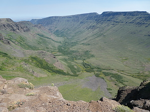
gorgeous basalt gorge
by Steph_and_Blake

 Likely In-Season!
Overview
A short, easy walk provides impressive views into a deep, glacially-carved gorge.


Warning
There are a few areas of sheer drops where a fall could be fatal.
remove free decal offer
History
The gorge is named for pioneer Reuben C. Kiger and his family. In 1874 they moved to the Steens Mountain vicinity but, fearing Native Americans, returned to western Oregon around 1878. Basque and Irish sheep herders used to roam the area with their flocks.

Geology
The U-shaped gorge was carved by Ice Age glaciers, leaving behind a deep valley of basalt. The gorge is about a half-mile deep and 6500 feet wide.

The Walk
From the parking area, follow the trail-of-use eastward to the rim. A sign offers information on the formation of the gorge and the fauna you might see. Take the time to walk past the sign so as to get a view of the “beginning” of the gorge. If you’re lucky you might happen to be there when fighter jets come from the south and drop down into the gorge. That ride must be a hoot!

2018-07-31 Steph_and_Blake


    Check out the Official Route.
    Leave No Trace and +Add a Triplog after your walk/tour to support this local community.
    WARNING! Hiking and outdoor related sports can be dangerous. Be responsible and prepare for the trip. Study the area you are entering and plan accordingly. Dress for the current and unexpected weather changes. Take plenty of water. Never go alone. Make an itinerary with your plan(s), route(s), destination(s) and expected return time. Give your itinerary to trusted family and/or friends.

     Permit $$
    None


     Directions
    or
     Road
    FR / Dirt Road / Gravel - Car Okay

    To walk/tour
    From Frenchglen, Oregon:
    Head southeast on OR-205 S for 0.2 miles. Turn left onto Steens Mountain Road for approximately 23 miles to the sign for Kiger Gorge. Turn left onto the side road and drive a short distance to a parking area.
    page created by Steph_and_Blake on Jul 31 2018 4:08 pm
     90+° 8am - 6pm kills
    helpcorrectionissue

    end of page marker