 Route Editor

| Guide | ♦ | 1 Triplog | 0 Topics |
details | drive | no permit | forecast | route |
stats |
photos | triplog | topics | location |
| 15 | 1 | 0 |
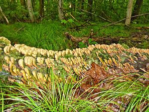
Mosquitoes'R'Us by kingsnake The Ice Age National Scenic Trail is a 1,200 mile trail that travels from the St. Croix River an hour northeast of Minneapolis, east towards Antigo, south to New Glarus -- home of an awesome microbrew -- east to Whitewater, then north to Sturgeon Bay, in scenic Door County, Wisconsin. The route roughly follows the "terminal moraine" -- the maximum glacial advance -- from the last Ice Age, which ended about 10,000 B.C. The Ice Age Trail is administered by the National Park Service, and is maintained by various public and private agencies.
Hike This segment starts from the public parking area in downtown New Fane, WI, right across from the Rusty Spur Saloon. (I am being facetious about New Fane’s size, but small towns in Wisconsin, are inevitably, clean, friendly, safe and great places to live.) Go north on County S for 150 yds., before turning east on County DD, uphill for a quarter mile to Ice Age Trail Marker Mile 26. Twenty-six what, I have no idea, as there are probably 1000 Ice Age Trail miles to the south and west, with at least another 100 to go to the north end in Door County. This segment is very similar to the 27 miles back to Glenbeulah: Firm, only occasionally muddy trail, with occasional rocks & roots, that generally follows the highline of eskers through dense, dark, deciduous forest. There are plenty of swampy kettles and heavy trailside undergrowth to encourage the local mosquito swarms. When you have to cross a creek, there is inevitably a wood bridge; likewise a wood walkway when the Ice Age Trail crosses a marshy area. You are never more than a half mile from a road, but being in rural Wisconsin, it is generally quiet along the trail, unless you are crossing a highway. This segment crosses two small roads, Kettle Moraine Scenic Dr. and Moraine Dr. (Sounds the same, but they aren’t.) WI-28 sees a fair amount of traffic, but not enough that you will be endangered crossing it, as is the case crossing WI-23, south of Glenbeulah. An out & back hike is 8.0 mi. / 450 AEG. Combined with the next segment south, to the Milwaukee River, an out & back hike is 12.0 mi. / 775 AEG. Check out the Official Route and Triplog. Leave No Trace and +Add a Triplog after your hike to support this local community. One-Way Notice This hike is listed as One-Way. When hiking several trails on a single "hike", log it with a generic name that describes the hike. Then link the trails traveled, check out the example. | |||||||||||||||||||||||||||||||||||||||||||||||||||||||||||||||||||||||||||||


