| Guide | ♦ | 1 Triplog | 0 Topics |
details | drive | no permit | forecast | route |
stats |
photos | triplog | topics | location |
| 0 | 1 | 0 |
Bunny Hill by kingsnake The Ice Age National Scenic Trail is a 1,200 mile trail that travels from the St. Croix River an hour northeast of Minneapolis, east towards Antigo, south to New Glarus -- home of an awesome microbrew -- east to Whitewater, then north to Sturgeon Bay, in scenic Door County, Wisconsin. The route roughly follows the "terminal moraine" -- the maximum glacial advance -- from the last Ice Age, which ended about 10,000 B.C. The Ice Age Trail is administered by the National Park Service, and is maintained by various public and private agencies.
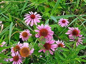
Hike This segment starts from the trailhead on the west bank of the Milwaukee River. The trail heads southwest across a fallow farm field. (Legally, no trespassing: It is marked.) The trail then passes between corn and soybean fields before entering a small woods. On the other side of the woods, the trail crosses another fallow field, then crosses Sandy Ridge Rd., before turning northwest towards US-45. Just before US-45, the Ice Age Trail skirts a protected wetland absolutely *riddled* with flowers. At US-45, the Ice Age Trail turns south for a hundred feet on the Eisenbahn State Trail, a gravelled jogging & biking path, before taking a tunnel under the divided highway. The Ice Trail then curves around a propane yard, and another farm field, before arriving at Prospect Dr., opposite the tiny Sunburst Ski Area. Tahoe, it ain’t. Head a quarter mile south on Prospect Dr. to parking Lot A (marked by a blue sign). Follow the tow lift uphill past the Ice Age Trail Kewaskum Segment sign. It’s steep climb, but only 150 ft. It’s the only significant elevation change between Glenbeulah and Kewaskum. After skirting some more farm fields, the Ice Age Trail goes straight through a soybean field. (Again, signed.) In 0.6 miles, after passing by some more farm fields, the segment ends at Ridge Rd. An out & back hike is 8.0 mi. / 625 AEG. Combined with the next segment north, to WI-28, an out & back hike is 12.0 mi. / 1000 AEG. Check out the Official Route and Triplog. Leave No Trace and +Add a Triplog after your hike to support this local community. | ||||||||||||||||||||||||||||||||||||||||||||||||||||||||||||||||||||||||||||
 Route Editor


