username
X
password
register
for free!
help
  🔥

Dane Canyon Upper, AZ

Guide 3 Triplogs  0 Topics
  0 of 5  
Fav
Wish
2
details
drive
no permit
forecast
🔥
route  
stats
photos
triplogs
topics
location
18 3 0
Statistics
tap row or icons for details
Difficulty 2.5 of 5
Route Finding 3 of 5
Distance One Way 5.1 miles
Trailhead Elevation 7,115 feet
Elevation Gain 342 feet
Accumulated Gain 555 feet
Avg Time One Way 3 hours
Kokopelli Seeds 6.95
 Interest Off-Trail Hiking & Seasonal Creek
 Backpack Possible - Not Popular
feature photo
Photos Viewed All MineFollowing
Inaugural Calculation on Button Tap!
18  2022-05-07
Barber Dane
chumley
18  2019-06-11
Upper Dane Canyon Loop
Oregon_Hiker
18  2018-08-28 markthurman53
36  2018-08-28
U Bar Dane Canyon Loop
markthurman53
Author
author avatar Guides 187
Routes 989
Photos 12,068
Trips 864 map ( 6,882 miles )
Age 72 Male Gender
Location Tucson, Arizona
Associated Areas
list map done
Payson Region
Historical Weather
Trailhead Forecast
Radar Map
Expand Map
Preferred Jul, Aug, Mar, Apr
Seasons   Early Spring to Early Winter
Sun  6:00am - 6:46pm
Official Route
 
2 Alternative
 
Historic Fire Perimetersacres
🔥 2019 Hart Fire5k
🔥 2016 Pinchot Fire3.9k
🔥 2009 Tucker Fire2.6k
🔥 1990 Dude Fire21.4k
🔥 View (All) - over Official Route 🔥


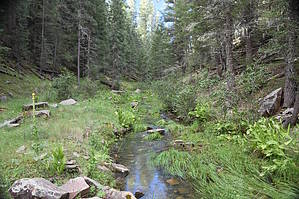
Rock hopping may be required
by markthurman53

Overview
This description is along Dane Canyon from the Dane Canyon intersection with the U Bar Trail to the intersection with the Barbershop Trail. Travel can be from either direction, but for this description, it is from the U Bar Trail. There is no trail along this creek, but there are areas where game/human routes have made walking easy.


Description
At Dane Creek along the U Bar Trail, head upstream. There are level areas off to one side or the other along this creek in many places that make walking easier; take advantage of this crossing over as needed. At no point on this hike did I come across obstacles that required me to climb up the sides of the canyon to get around them. This may not be true in higher water conditions.
remove free decal offer
During the summer, the canyon is lush and green, and the scenery is outstanding. If you are a photo buff, allow extra time to fool around with the camera. The upper reaches of this route have some short sandstone ledges/cliffs that make for interesting pictures. If you are “vewy vewy quiet”, you might come across elk, deer, or bear. At mile 1.25, there is a small canyon entering from the left (East), and that will lead up to Dane Cabin and spring; this could be an exit point back up to the U Bar Trail of the Cabin Loop Trail system. At 2.4 miles, Bill McClintock Draw enters again from the left (East), and this is also a possible exit point, this time back to the Barbershop Trail of the Cabin Loop Trail system. Another exit point is 4.1 miles in, an unnamed canyon coming in again from the left, and this will also lead back to the Barbershop Trail. Push on another mile (5.1 miles), and Dane Canyon crosses the Barbershop Trail. For this route, the elevation gain on Dane Creek is 345 feet, but it is hardly noticed because you are consistently admiring the views.

Recommendations
You can do Dane Canyon Upper the easy way or the hard way, depending on when you do it. When the canyon creek is running high, it can be difficult because of the amount of side canyon traversing done to avoid obstacles in the stream. When the creek is dry, it is far easier to walk but far less interesting and scenic. Picking a time when there is good water flow but not too deep is ideal. A summer day during the monsoons season is great but pick one between storms. On the trip I did, it was just two days after a very large storm; the water in the creek had time to recede to a manageable level.

2018-08-31 markthurman53


    Check out the Official Route and Triplogs.
    Leave No Trace and +Add a Triplog after your hike to support this local community.

    One-Way Notice
    This hike is listed as One-Way.

    When hiking several trails on a single "hike", log it with a generic name that describes the hike. Then link the trails traveled, check out the example.
    WARNING! Hiking and outdoor related sports can be dangerous. Be responsible and prepare for the trip. Study the area you are entering and plan accordingly. Dress for the current and unexpected weather changes. Take plenty of water. Never go alone. Make an itinerary with your plan(s), route(s), destination(s) and expected return time. Give your itinerary to trusted family and/or friends.

     Permit $$
    None


     Directions
    or
     Road
    FR / Jeep Road - Car possible when dry

    To hike
    Mogollon Rim Road (Forest Service Road 300) to either Forest service road 321 or 139 to the Barbershop trailhead. At FSR 139 take the barbershop Trail to Dane Creek. from FSR 321 take Barbershop to U Bar trail down to Dane Creek.
    page created by markthurman53 on Aug 31 2018 10:40 am
     90+° 8am - 6pm kills
    helpcorrectionissue

    end of page marker