 Route Editor

| Guide | ♦ | 1 Triplog | 1 Topic |
details | drive | no permit | forecast | 🔥 route |
stats |
photos | triplog | topic | location |
| 10 | 1 | 1 |
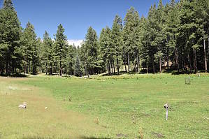
Canyon or Draw - what's in a name by markthurman53   Overview OverviewNot sure why some canyons get called a Draw and others a Canyon, but this one is a Draw. At least we don’t have to deal with the term gulch on the rim. Merritt Draw ends where it empties into Barbershop Canyon and its origin to the south at Forest Service Road 139 (FSR139). This description covers the upper portion from Maverick Canyon to FSR139 and starts just downstream of Maverick Canyon and heads upstream. The trailhead on the upper end is along FSR139, and the lower end is along 139c. This route is mainly off-trail, but there are some sections where you can follow along old logging roads. When old logging roads are mentioned, they are closed to motor vehicles; Forest Service Roads (FSR) are open to vehicles. Description From FSR139c, I took an old logging road to the rim of Merritt Draw and then headed downhill into Merritt Draw just downstream of where Maverick Canyon enters. Looking down into Merritt Draw, it appears it would be easy to navigate as the Canyon is relatively wide with level portions on either side of the creek. I will soon find out this won’t be the case for long. I ran into a bear at the junction with Maverick Canyon, and since we were 50 yards apart, we spent a few seconds checking each other out. I was able to get some pictures. Heading upstream From Maverick Canyon, the route gets very choked up with trees and tough to navigate. Merritt Canyon was not running at this point. At first, I tried navigating the canyon bottom, but this was too difficult. Then I tried climbing up the canyon's west wall a bit to try to get around the debris in the canyon bottom, and this wasn’t any better. After 0.4 miles from where I entered Merritt Canyon, I called it quits. For the hardy die-hards, you could continue up the creek and wrestle with the logs and brush. I headed up the East side of Merritt Canyon to an old logging road and followed it as it paralleled the creek for about a mile, where it then crossed Merritt creek. It looks like you could drop back down into the creek a little before this, but I opted not to. Once at the crossing, I headed back up Merritt Creek, which by now I would call Merritt Meadows. From here to FSR139, the creek follows a large open meadow, which reminded me of the Kaibab Plateau and the large meadows there, only not quite as big. On the lower end of the meadow is Merritt Spring, and the upper end is Whistling Spring. Tall fences have been put around two portions of the meadow to keep animals out. There were also some fences around what looked like apple trees. Shortly after the meadow ends, you follow a dirt road to FSR139, where Merritt Draw has its origin.
Like most Creek hiking, you want to pick a time when they are not running too full or too dry. Too full makes them hard to navigate, too low, and they aren’t quite as scenic. I like the monsoon season a few days after a good rain. On this route, the upper half portion where it travels through meadows, winter with snow on the ground would be extraordinary. Check out the Official Route and Triplog. Leave No Trace and +Add a Triplog after your hike to support this local community. One-Way Notice This hike is listed as One-Way. When hiking several trails on a single "hike", log it with a generic name that describes the hike. Then link the trails traveled, check out the example. | ||||||||||||||||||||||||||||||||||||||||||||||||||||||||||||||||||||||||||||||||||||||||||||||||||||||||||||


