 Route Editor

| Guide | ♦ | 2 Triplogs | 1 Topic |
details | drive | no permit | forecast | 🔥 route |
stats |
photos | triplogs | topic | location |
| 15 | 2 | 1 |
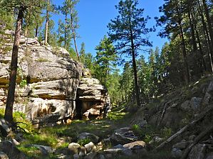
Less filling! Tastes great! by kingsnake   Overview OverviewMiller Canyon is a 14-mile canyon that flows downhill, north from the Mogollon Rim at High View Point to East Clear Creek, just downstream from C.C. Craigan Reservoir. Miller Canyon is bounded by Miller Ridge, Blazed Ridge, McCarty Ridge, and Battleground Ridge. FR 141H separates the 3.5-mile upper section from the middle section, while the junction with East Miller Canyon, separates the middle from the lower 6.0 miles. Middle Miller Canyon is 4.5 miles of relatively easy canyon crawling. It is never more than 200 ft. deep. For the most part, it is higher and steeper on the east slope; lower and more moderate on the west. It is from 20-100 ft. wide at its bottom, with no major obstacles that require low crawling or side-sloping a higher contour line. There is no tangled brush or grab & stabs.
Both east and west slopes have many draws, or other relatively easy egress points, if you want to cut the loop short, or in case of a flash flood. Hike The loop starts from the large grassy area/campground a mile north of FR 141H on FR 320. You can follow my route, or head across FR 320 straight at the obvious low area. Just follow that drawdown to FR 9350E. After 0.75 miles on the old forest road, drop down one of the draws to the canyon bottom. Follow the canyon bottom north for 4.5 miles to the junction with East Miller Canyon. If you follow my route, just before that junction, on the east slope, there is a steep 150 ft. tall draw that has a game trail up to FR 320. Then just follow the forest road back for 3.5 miles to the trailhead. Check out the Official Route and Triplogs. Leave No Trace and +Add a Triplog after your hike to support this local community. One-Way Notice This hike is listed as One-Way. When hiking several trails on a single "hike", log it with a generic name that describes the hike. Then link the trails traveled, check out the example. | ||||||||||||||||||||||||||||||||||||||||||||||||||||||||||||||||||||||||||||||||||||||||||||||||||||


