Route Editor

| Guide | ♦ | 2 Triplogs | 0 Topics |
details | drive | no permit | forecast | route |
stats |
photos | triplogs | topics | location |
| 14 | 2 | 0 |
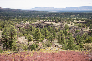
smells like one would expect by jochal A short distance from the I-40, this is a convenient way to explore the remnants of volcanic activity while enjoying beautiful scenery. The hike optionally follows part of the Continental Divide Trail. The trail is well marked, and there should be a free NPS booklet at the trailhead. The booklet is also available as pdf from the NPS El Malpais website. Hike Hiking the loop clockwise is recommended and probably most popular. Most of the points of interest in the NPS booklet are in the first half of the loop.
After the Bat Cave and Xenolith Cave stop, the trail hits a fence and then follows the fence to the right. Lava Trench is reached right before the Cinder Cone. The Lava Trench is like a Lava Cave, but with a collapsed roof. El Calderon Cinder Cone can be hiked by either doing a loop around the rim, or just going to the overlook and back. The overlook is just above the steps on the right. We chose to go left, up the switchbacks, do the full loop, and and return by the steps. After touring the Cinder Cone, there is a choice to return using the complete loop trail or take a shortcut on Cerritos de Jaspe Road. Continuing the full loop is another 2 miles on top of the 2-2.5 miles already hiked, while taking the shortcut is only 0.9 miles. Hiking the full loop gives a longer walk through beautiful scenery, and the novelty of hiking for a mile on the Continental Divide Trail. Check out the Official Route and Triplogs. Leave No Trace and +Add a Triplog after your hike to support this local community. | |||||||||||||||||||||||||||||||||||||||||||||||||||||||||||||||||||||||||||||||||||||||||||||||||||