 Route Editor

| Guide | ♦ | 5 Triplogs | 1 Topic |
details | drive | no permit | forecast | 🔥 route |
stats |
photos | triplogs | topic | location |
| 14 | 5 | 1 |
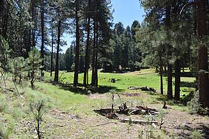
Don't know who Merritt is but he has a Draw by markthurman53   Overview OverviewMerritt Draw has its origin at Forest Service Road (FSR) 139 along the Dick Hart Ridge to the east and the ridge to the south separating Merritt Draw from Barbershop Canyon. The lower end is where it empties into Barbershop Canyon for a length of about 4.9 miles. Maverick Canyon is the only Major side Canyon and comes in from the east off of Dick Hart Ridge. This description is for its entirety but is typically done in portions as part of a greater loop hike. Published descriptions of possible loop hikes are Merritt - Barber Short Loop, Merritt Draw Lower Loop, Merritt Draw Upper, and a few other possible loop hikes. This description and route is a compilation and summary of two separate hikes. The description is given from FSR 139 and ends at Barbershop Canyon. Most of this route is off-trail, and some route-finding and map reading skills are required. A GPS or Topo map is essential if there is a need to exit the canyon and return via one of the ridges. Description Merritt Draw can be accessed from FSR 139 at the junction with FR 9735p (not marked), or you can take FR 9735p for about 0.5 miles where the road is blocked at Whistling Spring. The first 1.1 miles from Whistling Spring, the route follows a well-worn footpath through wide meadows along the west side. At about 0.7 miles from Whistling Spring is Merritt Spring. There are multiple fenced-off areas along this meadow to protect sensitive plants life and riparian areas. The trail skirts along all of these. There appear to be some apple trees (my guess didn’t check them out) in the meadow that were also fenced off. FR 9735p crosses the meadow 1.1 miles from Whistling Spring. At this point, Merritt Draw transitions from a wide meadow to a narrow and deeper canyon. I recommend taking FR 9735p along the east side of Merritt Draw unless you are into serious bushwhacking along the inner canyon. At about 0.8 miles along FR 9735p, head down to Merritt Draw again; this will put you in the draw just upstream of where Maverick Canyon comes in from the west. From this point, the Canyon is reasonably easy to navigate to Barbershop Canyon. There is some navigating around deadfall and rocks but nothing major; there were no apparent signs of a trail or game routes. Drift Fence Spring is about 0.5 miles downstream from the junction with Maverick Canyon, but I didn’t see it; supposedly, it is on the west side of Merritt draw. Merritt draw ends at the junction with Barbershop Canyon and also the junction with the U Bar Trail (Part of the Cabin Loop Trail system).
Like most Creek hiking, you want to pick a time when they are not running too full or dry. Too full makes them hard to navigate and too low, and they aren’t quite as scenic. I like the monsoon season a few days after a good rain. The upper half portion where it travels through meadows, winter with snow on the ground would be extraordinary. Check out the Official Route and Triplogs. Leave No Trace and +Add a Triplog after your hike to support this local community. One-Way Notice This hike is listed as One-Way. When hiking several trails on a single "hike", log it with a generic name that describes the hike. Then link the trails traveled, check out the example. | |||||||||||||||||||||||||||||||||||||||||||||||||||||||||||||||||||||||||||||||||||||||||||||||||||||||||||||||||||||||||||||||||||||||||||||||||||||||||||||||||||||||||||||||||||||||||||


