 Route Editor

| Guide | ♦ | 12 Triplogs | 1 Topic |
details | drive | no permit | forecast | 🔥 route |
stats |
photos | triplogs | topic | location |
| 212 | 12 | 1 |
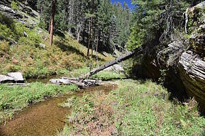
Must see even if you don't need a haircut by markthurman53   Overview OverviewBarbershop Canyon has its origin at the Rim Road, Forest Service Road (FSR) 300, right at the Mogollon Rim. The lower end is East Clear Creek, but for this guide, the lower end is at the junction with Dane Canyon for a length of about 10.4 miles. To the West of Barbershop Canyon is Dick Hart Ridge that separates Barbershop Canyon from Bear, and to the East is McClintock Ridge that separates Barbershop Canyon from Dane Canyon. Dane Canyon and Merritt Draw are the two significant canyons that drain into Barbershop Creek, Merritt from the Southwest off Dick Hart Ridge, and Dane Canyon from the Southeast. Major trails that cross Dane Canyon are the Barbershop Trail near its Southern end and the U Bar Trail Near its Northern end. This description is for its entirety but is typically done in portions as part of a greater loop hike. Possible loop hikes are Barbershop Cyn – Dane Cyn Loop, Barbershop Cyn Upper – Merritt Draw Upper, Barbershop Cyn Upper Loop, and a few other possibilities. This description and route is a compilation and summary of three separate hikes. Most of this route is off-trail, and some route-finding and map reading skills are required. A GPS or Topo map is essential in case there is a need to exit the canyon and return via one of the ridges. A direct exit at the Barbershop/Dane is not the intent of this description and might be unsafe; plan accordingly.
From the Rim Road, FSR 300, 0.5 miles east of FSR 139, is as good a spot as any to head down Barbershop Canyon. There is a small dirt road/campsite along FSR300; park there, head downhill, crossing over the old General Crook Trail almost immediately. The route drops down quickly but not too steep, and in about 100 yards, there is a rock cliff that seems to be a good place to call the headwaters. It was at this point I noticed the stream bed became wet and was running. The entire side of this hill near this rock was seeping with water. This was after the monsoon rains, so it probably won’t be wet in dryer times of the year. From this point on until the Barbershop Trail crossing, there is a good route to follow. It seems the elk have a good trail crew working on this, in better condition than some trails I have been on. There were elk, deer, and even a set of bear prints on this route. It was very easy walking along this portion of the canyon. After about a half-mile, the canyon opens up with grassy flats and a game trail on either side of the creek. I choose the trail on the west side of the creek almost the whole way to the Barbershop Trail. The remnants of 3 tanks along this creek at 1, 1.4, and 1.7 miles still hold back a little water, but mostly they have been breached. There is a set of interesting caves on the east side of the canyon at 1.8 miles; I wonder if bears use these. At 2.5 miles, Barbershop Creek crosses the Barbershop Trail. Easy walking along a game trail that continues downstream of the Barbershop Trail for another 2 miles (4.5 miles on Barbershop Creek), except now the occasional fallen tree and stream crossings. The creek downstream from Barbershop could be difficult to navigate during high water periods because of stream crossings and the lack of flat areas above the creek. After 5 miles, the Canyon becomes more “V” shaped, and crossing the creek becomes more frequent to avoid obstacles. Still easily navigated, assuming the water isn’t running too high. The rest of the route along Barbershop Creek remains the same, slower going but very manageable. Merritt Draw comes in from the west at 8.7 miles, and at this junction, the U Bar Trail also crosses Barbershop Canyon. The U Bar Trail is part of the Cabin Loop system of trails. Dane Canyon comes in from the east at 10.4 miles. This is a very interesting canyon to hike. It starts with a walk along a small stream through a forest. It then opens up to a creek with a wide base and grassy flats on either side and ends with a “V” shaped Canyon with sandstone cliffs occasionally on either side of the creek with marshy areas intermittently along the way. McClintock Ridge remains on the east side, with FSR 145 running the length of the ridge to the Dane Creek intersection with Barbershop Creek. An unnamed ridge (part of Dick Hart Ridge separated by Maverick Canyon) is on the west side of Barbershop Creek from the Barbershop Trail to the Junction with Merritt Draw. FSR 139c follows along this ridge. After Merritt Draw, Dick Hart Ridge is to the west of Barbershop Creek, with FSR 139 following along that. These FSRs are all accessible and provide access for shorter loop hikes. Recommendations Like most Creek hiking, you want to pick a time when they are not running too full or dry. Too full makes them hard to navigate and too low, and they aren’t quite as scenic. I like the monsoon season a few days after a good rain. Fall could be interesting for the fall color change, but the streams will probably be dry unless we had a wet September early October. Probably best to do this Canyon in parts as part of a loop hike but could be done with as a car shuttle. Although it is only 10 miles, it will seem like more because there is no trail to follow, so the going is slower. Check out the Official Route and Triplogs. Leave No Trace and +Add a Triplog after your hike to support this local community. One-Way Notice This hike is listed as One-Way. When hiking several trails on a single "hike", log it with a generic name that describes the hike. Then link the trails traveled, check out the example. | |||||||||||||||||||||||||||||||||||||||||||||||||||||||||||||||||||||||||||||||||||||||||||||||||||||||||||||||||||||||||||||||||||||||||||||||||||||||||||||||||||||||||||||||||||||||||||||||||||||||||||||||||||||||||


