Route Editor

| Guide | ♦ | 36 Triplogs | 1 Topic |
details | drive | no permit | forecast | 🔥 route |
stats |
photos | triplogs | topic | location |
| 318 | 36 | 1 |
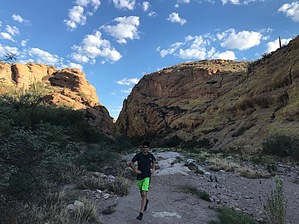
Great hike, outstanding trail run by bezzantine  A similar loop has been already published, but this cuts further west on the first/last leg, giving probably the best panoramic view of the loop, and rounding the mileage to an even 6.0. I like to park at the more western, "horse" lot, run the road to the trailhead lot, and end back at the horse lot. Nice clean loop. In the hot months, a dawn start this way keeps you in the shade for maximum time. The trail is almost always clear, but there are a few key intersections, so using the GPX route is highly recommended. A similar loop has been already published, but this cuts further west on the first/last leg, giving probably the best panoramic view of the loop, and rounding the mileage to an even 6.0. I like to park at the more western, "horse" lot, run the road to the trailhead lot, and end back at the horse lot. Nice clean loop. In the hot months, a dawn start this way keeps you in the shade for maximum time. The trail is almost always clear, but there are a few key intersections, so using the GPX route is highly recommended.Half an hour east of Mesa, this has become my favorite local trail run. First Water Trailhead is National Forest, but no pass/fee is required. Aside from a few short stretches of running on "baby head" size streambed rocks, the elevation shifts and terrain are (for the area) unusually well-suited to trail running. There is no major peak to bag, but the trip delivers several awesome 360º views of the northern Supes out to Weaver's Needle. The real star though is the bit through a decently tight, relatively shady, steep-walled canyon.
Check out the Official Route and Triplogs. Leave No Trace and +Add a Triplog after your hike to support this local community. | |||||||||||||||||||||||||||||||||||||||||||||||||||||||||||||||||||||||||||||||||||||||||||||||||||||||||||||||||||||||||||||||||||||||||||||||||||||||||||||||||||||||||||||||||||||||||||||||||||||||