Route Editor

| Guide | ♦ | 1 Triplog | 0 Topics |
details | drive | no permit | forecast | map |
stats |
photos | triplog | topics | location |
| 13 | 1 | 0 |
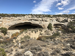
Flintstone Habitat by AZLOT69 Once you enter the cave and look up you realize the front section of the cave has broken away from the mountain creating a natural bridge/ arch. There have been many cave ins from this soft rock and while it's pretty obvious to assume that it was used for habitation at some time. However there is no evidence other than the rock art. It did appear that someone had done some digging in the rear of this first cave.
From here you can return the way you came or continue to the west on one of several trails to the next big cave. Look hard beyond the graffiti for any rock art, then continue to the west to another large cave hidden from view. A large snake and figure are on the left side of this cave. You can continue westward to find yet another cave. By this time you are probably ready to return to the trailhead. Find a way across the draw and hike uphill back to your vehicle. Check out the Triplog. Leave No Trace and +Add a Triplog after your hike to support this local community. | |||||||||||||||||||||||||||||||||||||||||||||||||||||||||||||||||||||||||||||||||||