username
X
password
register
for free!
help
 This is likely a great time to hike this trail!  Check out "Preferred" months below, keep in mind this is an estimate.
  

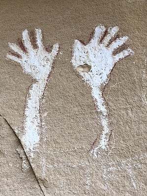
Waving Hands Rock Art, CO

Guide 2 Triplogs  0 Topics
  3 of 5  
Fav
Wish
0
details
drive
permit
forecast
route  
stats
photos
triplogs
topics
location
15 2 0
Statistics
tap row or icons for details
Difficulty 0.5 of 5
Distance Round Trip 0.35 miles
Trailhead Elevation 5,999 feet
Elevation Gain 28 feet
Accumulated Gain 28 feet
Kokopelli Seeds 0.49
 Interest Historic
unreported if dogs are allowed
editedit > ops > dogs to adjust
feature photo
Photos Viewed All MineFollowing
5  2020-04-24 PaleoRob
10  2018-10-04 AZLOT69
Author
author avatar Guides 595
Routes 0
Photos 0
Trips 247 map ( 429 miles )
Age ?
Location
Associated Areas
list map done
Northwest Region
Historical Weather
Trailhead Forecast
Radar Map
Expand Map
Preferred May, Sep, Apr, Jun
Sun  5:46am - 6:40pm
Official Route
 
0 Alternative


remove free decal offer

 Likely In-Season!
Guide Needed
Publish Full Detail Guide


Use +Add above to share photos and triplogs
Great little roadside area to explore. Not only will you find two great Rock art sites, there are two great natural arches.


    Check out the Official Route and Triplogs.
    Leave No Trace and +Add a Triplog after your hike to support this local community.
    WARNING! Hiking and outdoor related sports can be dangerous. Be responsible and prepare for the trip. Study the area you are entering and plan accordingly. Dress for the current and unexpected weather changes. Take plenty of water. Never go alone. Make an itinerary with your plan(s), route(s), destination(s) and expected return time. Give your itinerary to trusted family and/or friends.

     Permit $$

     Directions
    or
     Road
    Paved - Car Okay

    To hike
    Highway 139 mile post 53.5. South of Rangeley, Colorado.
    page created by AZLOT69 on Oct 05 2018 7:10 am
     90+° 8am - 6pm kills
    helpcorrectionissue

    end of page marker