|
tap row or icons for details
|
| Difficulty |
|
1.5 of 5 |
| Route Finding |
|
2 of 5 |
| Distance Round Trip |
|
1 mile |
| Trailhead Elevation |
|
3,962 feet |
| Elevation Gain |
|
40 feet |
| Avg Time Round Trip |
|
1 hour |
| Kokopelli Seeds |
|
1.2 |
| Interest Ruins, Historic & Seasonal Waterfall | | Backpack No | |
| | |
|
|
|
list |
map |
done |
Southeast Region |
| | |
|
| |
|
|
Historical Weather |
| Trailhead Forecast | | |
|
 |
|
|
| Preferred Apr, Oct, May, Mar → 9 AM |
|
|
|
Seasons Early Spring to Late Autumn |
|
|
| | |
| |
Named Locations Coordinate Links
| |
|
| help future hikers |
| post a gps route now |
| | |
| |
|
|
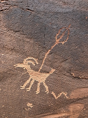
Peace, Love, Rock and Roll by AZLOT69   For a fun afternoon searching for rock art in the Moab area, specifically on the southwest side of the Colorado River as it flows thru Moab, Moonflower would be your first stop. The roadside rock art is located on the right side of the parking area and while it has been vandalized, there are some nice images. Just to the left of the petroglyphs is a feature referred to as " Mad Jack Crack ". The crack is a natural feature that forms a type of chimney to the top of the mountain. Many logs have been jammed into this "chimney" making it possible for the adventurous to climb straight up to the top. While you are here, take a hike up Moonflower which is a box canyon. The hike is about one mile round trip. High canyon walls surround you. On the day we were there it was raining which resulted in a two high waterfalls and pool at the box end of the canyon. On the way back we noticed what appeared to be rock walls high on the right side. We climbed up and photographed a rock structure. Ancient, I'm not sure but part off the adventure. |
 Route Editor