Route Editor

| Guide | ♦ | 6 Triplogs | 0 Topics |
details | drive | permit | forecast | route |
stats |
photos | triplogs | topics | location |
| 16 | 6 | 0 |
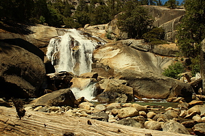
raging river by NatureKopelli This hike has it all: great views, well maintained and easy to follow trail, hike next to an amazing river, some elevation change to get the heart pumping a little, and a refreshingly cool and misty waterfall that engages all your senses. Hike The hike begins at the Copper Creek trailhead located at the end of highway 180. A small permit station is located at the trailhead. The hike begins on a level, sandy surface in an open area with views of the canyons rising up on all sides. The first two miles of the hike are fairly level, then the trail takes a left turn to Mist Falls. From this point, the climb, which is gradual and hardly noticeable, begins. This section of the hike is in the shade of a forest along a raging river cascading over boulders. At one point, the hike reaches a large granite overlook point with views of the surrounding canyons, the river and forest below. From this point, the falls are a short distance away and marked by a sign along the trail. One can continue on to Paradise Valley and other connecting hikes. The falls are misty, so protect your camera equipment if this is a concern.
Note In the summer, the temperature in the canyon can reach into the 100s. It was 100 degrees on my hike in July. Sequoia NP NPS Details Mist Falls This sandy trail follows the glaciated South Fork Canyon through forest and chaparral, past an impressive show of rapids and cascades, to one of the largest waterfalls in Sequoia and Kings Canyon National Parks. The first part of this 8-mile round trip is relatively flat; during the last mile to the falls, the trail gains 600'. The average time for this trip is 4 to 5 hours. Check out the Official Route and Triplogs. Leave No Trace and +Add a Triplog after your hike to support this local community. | ||||||||||||||||||||||||||||||||||||||||||||||||||||||||||||||||||||||||||||||||||||||||||||||||||||