Tusher Tunnel, UT • Hike


Tusher Tunnel, UT

Guide 1 Triplog Mine 0 0 Topics
 
2 of 5 
Fav
Wish
0
details
drive
permit
forecast
map
stats
photos
triplog
topics
location
16 1 0
Statistics
tap icons for details
Difficulty 2 of 5
Route Finding 2 of 5
Distance Round Trip 0.5 miles
Trailhead Elevation 4,846 feet
Elevation Gain 88 feet
Avg Time Round Trip 1 hour
Kokopelli Seeds 0.94
 Interest Historic
 Backpack No
feature photo
Photos Viewed All MineFollowing
16  2018-10-09 AZLOT69
Author
author avatar Guides 177
Routes 249
Photos 8,849
Trips 2,034 map ( 16,705 miles )
Age 71 Male Gender
Location Gold Canyon, AZ
Associated Areas
list map done
Southeast Region
Historical Weather
Trailhead Forecast
Expand Map
Preferred Apr, Oct, May, Sep → 8 AM
Seasons   Late Spring to Late Autumn
Sun  6:43am - 6:18pm
Route
 
0 Alternative
 
 Water
Nearby Area Water
[ View More! ]
no photo labels yet
+Add > Photos to this Guide
then label as applicable
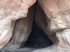
Break On Thru To The Other Side
by AZLOT69

 
Warning
You should have a map and GPS. There are many side roads, stick to the directions. DEEP SAND.
Bring a flashlight.
Hike
Getting to the trailhead is an adventure in itself. From the trailhead hike about one hundred yards. Follow the BLM arrow left and climb up the ridge then right go around the corner to the left. A cave opening is ahead. This is a natural cave( tunnel) created in sandstone by water eroding from above. The tunnel is about 200 yards long and it curves so you can't see straight thru it. A good flashlight will be a big help. The ceiling can be low in sections. When you get to the other side the distant views are awesome as water and wind has further carved the landscape. You can return from here or continue exploring. There is evidence of art least nine partial caves starting to be formed from this side of the mountain. Each worthy of exploring for rock art. The walls are full of cowboy art, Indian art, and just plain graffiti. Explore to your heart's content.

Check out the Triplog.

Leave No Trace and +Add a Triplog after your hike to support this local community.

2018-10-09 AZLOT69
    WARNING! Hiking and outdoor related sports can be dangerous. Be responsible and prepare for the trip. Study the area you are entering and plan accordingly. Dress for the current and unexpected weather changes. Take plenty of water. Never go alone. Make an itinerary with your plan(s), route(s), destination(s) and expected return time. Give your itinerary to trusted family and/or friends.

     Permit $$

     Directions
    or
    or
     Road
    Strictly 4x4

    To hike
    Take highway 191 13 miles north of Moab to Mill Canyon Road, turn left. Go 0.9 miles to first road on right signed Tusher Tunnel. Proceed 1.9 miles turn left. Go 0.9 miles turn right. Go 1.1 miles. Turn left to trail head.
    page created by AZLOT69 on Oct 09 2018 8:12 pm
    helpcorrectionissue

    end of page marker