username
X
password
register
for free!
help


Moab Wind Caves, UT

Guide 1 Triplog  0 Topics
  4 of 5  
Fav
Wish
0
details
drive
permit
forecast
map
stats
photos
triplog
topics
location
13 1 0
Statistics
tap row or icons for details
Distance One Way 1 mile
Trailhead Elevation 4,001 feet
Elevation Gain 90 feet
Kokopelli Seeds 1.3
 Interest Off-Trail Hiking
feature photo
Photos Viewed All MineFollowing
13  2018-10-10 AZLOT69
Author
author avatar Guides 595
Routes 0
Photos 0
Trips 247 map ( 429 miles )
Age ?
Location
Associated Areas
list map done
Southeast Region
Historical Weather
Trailhead Forecast
Expand Map
Preferred Apr, Oct, May, Mar
Sun  5:51am - 6:43pm
0 Route
 
0 Alternative


remove free decal offer

 
Warning
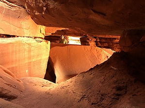
The route to this adventure is an adventure in itself. Very remote, no phone signal, strictly 4 x 4 Road. Be prepared for anything including spending the night.


Hike
This is a bushwhack. Utah is blessed with another work of art prepared by mother nature. Time, water, and wind has created a labyrinth of natural caves to explore. Great fun for anyone, including families. BRING A FLASHLIGHT.


    Check out the Triplog.
    Leave No Trace and +Add a Triplog after your hike to support this local community.

    One-Way Notice
    This hike is listed as One-Way.

    When hiking several trails on a single "hike", log it with a generic name that describes the hike. Then link the trails traveled, check out the example.
    WARNING! Hiking and outdoor related sports can be dangerous. Be responsible and prepare for the trip. Study the area you are entering and plan accordingly. Dress for the current and unexpected weather changes. Take plenty of water. Never go alone. Make an itinerary with your plan(s), route(s), destination(s) and expected return time. Give your itinerary to trusted family and/or friends.

     Permit $$

     Directions
    or
     Road
    Strictly 4x4

    To hike
    From downtown Moab, highway 191 locate the MC Donald s restaurant and turn west on Kane Creek Blvd. Go 11.4 miles to a junction. Bear right headed for Hurrah Pass. It's. 3 miles to Hurrah Pass. Bear left and continue 2.5 miles to an unsigned intersection and bear left. Go 1.8 miles and turn left. You can see your destination from here. The sandstone Massif is .4 miles.
    page created by AZLOT69 on Oct 10 2018 6:24 pm
     90+° 8am - 6pm kills
    helpcorrectionissue

    end of page marker