Route Editor

| Guide | ♦ | 3 Triplogs | 0 Topics |
details | drive | no permit | forecast | route |
stats |
photos | triplogs | topics | location |
| 33 | 3 | 0 |
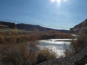
petro & picto below the crack by Steph_and_Blake  A fairly easy, mostly level hike through a pretty canyon featuring rock writing. The trail ends at the Colorado River. Note This hike is written up in the Grand Junction Falcon guide, and more than 5 GPS routes can readily be found on the internet, so we felt it acceptable to post this Guide here.
Not much is known about the ancient history of this canyon, but it was once inhabited by the Fremont peoples. Hike The hike starts from the eastern side of the parking area and quickly drops into the creek bed. While there are no trail signs, it is very easy to follow the beaten path. At about 0.4 miles, you'll notice an offshoot trail on your left. This is where you'll find the first pictograph panel. Continuing down-canyon, you'll come to a big "crack" in the creek bed. It might be possible to shimmy and stem your way down the crack, but it appears that most folks back-track a couple dozen feet and proceed up the side canyon to the east. After a short distance up this side canyon, you'll come to a "Y". Take a right and continue down McDonald Creek Canyon (with the creek bed below you and to your right). Although we did not find them, the BLM website says there are both petro- and pictographs below the "crack" or drop-off. The trail eventually takes you back down to the creek bed, which you will cross numerous times. By now, the canyon walls are much taller, and the cottonwood trees have grown to a considerable size. The hiking is easy-cruising, and you'll probably find yourself peeking into various alcoves and scrutinizing the desert varnish for rock writing. At around the 2-mile mark, you'll see another off-shoot trail to your left. It leads to the base of a large alcove that contains more pictographs high-high up on the wall. From here, it's just another 10 minutes through some overgrowth to the Colorado River. Return the way you came. Water Sources There was no running water in the creek at the time of our hike, and we saw no mention of nearby springs, so carry in all that you'll need. Camping Developed and undeveloped campsites are available throughout Rabbit Valley. Check out the Official Route and Triplogs. Leave No Trace and +Add a Triplog after your hike to support this local community. | ||||||||||||||||||||||||||||||||||||||||||||||||||||||||||||||||||||||||||||||||||||||||