 Route Editor

| Guide | ♦ | 4 Triplogs | 0 Topics |
details | drive | permit | forecast | route |
stats |
photos | triplogs | topics | location |
| 30 | 4 | 0 |
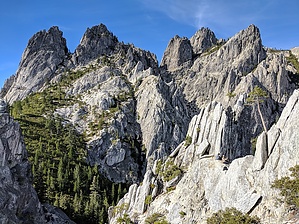
A Granite Spire Playground by lojones5  This is an uphill trek to a huge granite playground with incredible views in every direction. At the end of the trail you can explore as much as you'd like around relatively easy to climb granite structures. You will reach cliff edges with sheer drops many hundreds of feet below. You will encounter sweeping views of the surrounding landscape, Mt. Shasta, and the impressive crags themselves. To top it all off, there is Castle Dome standing prominently like a smaller version of Half Dome--summitable to thrill-seekers with no fear of heights and an eye for bouldering. Warning There is no official trail up Castle Dome, nor any of the granite structures near trail end. The scramble up Castle Dome is doable for adventurers without significant climbing experience, but it is no simple endeavor. The last quarter of the climb has some dangerous exposure and should only be attempted by those confident in their bouldering skills.
Castle Crags was formed about 170 million years ago by rising lava beneath the Earth's surface that solidified and was eventually sculpted by glaciers and erosion into the state it is in today. Hike The hike is uphill and is mostly forested in the beginning which is nice, but fairly uneventful compared to what is yet to come. After a little over than 2 miles of uphill forest hiking, you will reach a nice sign indicating Castle Crags Wilderness over a background of your first glimpse of Castle Dome. From here on out the trail continues uphill, but the views become so great that you'll forget about yourself and just bask in the glory of the unfolding beauty as you trek onward towards the ever impressive granite formations. When you reach the end of the trail, you are going to want to explore some of the more accessible granite structures that are typically quite easy to boulder on up. Each will offer a unique and awesome view. Some spots will offer a fantastic view of Mount Shasta, and all will offer views of huge granite structures. Plan to spend some time at the top to make the most of your hike. Water Sources There is a side trail about halfway up to Indian Springs. Camping Castle Crags State Park offers camp sites before the trails begins. There is some evidence of camping on Castle Dome trail, but I don't believe it is allowed. Check with a ranger to be sure. Check out the Official Route and Triplogs. Leave No Trace and +Add a Triplog after your hike to support this local community. One-Way Notice This hike is listed as One-Way. When hiking several trails on a single "hike", log it with a generic name that describes the hike. Then link the trails traveled, check out the example. | |||||||||||||||||||||||||||||||||||||||||||||||||||||||||||||||||||||||||||||||||||||||||


