Route Editor

| Guide | ♦ | 2 Triplogs | 0 Topics |
details | drive | no permit | forecast | route |
stats |
photos | triplogs | topics | location |
| 11 | 2 | 0 |
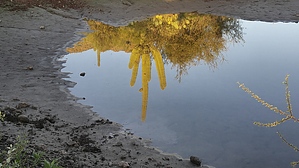
Is This For Real or a Mirage? by Metalrunner   Disclaimer DisclaimerIf you are new to cross-country travel/navigation, I believe this is a good route for you. Using this guide in conjunction with the Official Route, coordinates, and your experience should present a challenge, a goal you can accomplish. This terrain is, at the same time, harsh and forgiving. Bare skin will be scratched and clothing snagged, hat pulled from your head and maybe your sunglasses will be lost. Your footing will be loose, rocky, wet and slippery, and littered with cactus, an inexperienced dog will resemble a porcupine (cactus) in no time. Vegetation will hide your next step or tie you up. Always know where you are, where you are going, and how to get there. With cross country travel there is no trying to stay on a trail, which when lost, can eat up precious time in the attempt to regain the tread. You are here, you need to get there, so find the path of least resistance. This route incorporates the use of washes as the main arteries for travel. You will find it easy to gain a visual of landmarks, used as destinations along the route. You may need to gain a better vantage to see that next landmark and that’s easy to do in this desert. We encountered several donkeys, several heads of cattle, and (up close) two, bulls. I have been visiting this wilderness since Y2K and can say the donkey population has grown. Those first visits here, seeing a donkey or two was comparable to a Gila Monster sighting. Unfortunately, cattle have always been present on my visits. Besides the damage done by nonnative species, their manure is omnipresent on the trails, in washes, and along/in the water.
From the cattle guard, head down (north) on the road for about 200 feet and drop off the bank to cross Castle Creek. Keep your eyes peeled for trail markers to get you across the creek bed and to the mouth of a side canyon that is about 500 feet SW of the cattle guard. Here you’ll find a BLM podium-style trail sign-in. From here the navigation should be easy, following the Spring Valley trail to Garfias Wash a distance of about 2.5 miles. Heading west, mostly south, and just before dropping into Garfias Wash, west again. You will be contouring the base of the impressive ridge to the west. Eventually reaching the south end, turning west, and dropping into Garfias Wash. Once in the wash, make a mental note of landmarks as you will be returning here and will need to find your trail to the cattle guard. Of note here is the island in the middle of the wash. On your return, if you are on the north side of the island, finding the trail will be easier. Being on the south side, missing the trail is easy. Also, note the visible cairns at this junction. Take time to find the very large cairn that sits high above the wash on the north bank. The rest of your route is cross country, no trails or cairns are needed. Cross the wash and head downstream (SE). In about 700 feet, turn SW up the major drainage coming in from your right. Stay in this wash, heading upstream for approximately 1.5 miles. This is a very scenic, tight, and wandering canyon. You will encounter standing/running water from springs not disclosed on a topo map. In a couple of spots, the vegetation (trees) are dense and we chose to climb out (right/north) of these oases and dropped back in as soon as possible. Continue on to the point, 33.9394 -112.3731 where you will leave the wash and start a southern ascent to a High Saddle at 33.9340 -112.3824. On the ridgeline to the SW, you will see a pyramid-shaped peak (“Pyramid Peak”). Head for this peak, eventually traversing its west face and climbing into High Saddle. High Saddle is the summit on this route, with views of Lake Pleasant and the Bradshaw mountains. To the SW is Peak 3651, which I believe is the high point in the wilderness. Further west is Garfias peak, just out of view. Burro Flats is below, to the south, the next destination. To the west of High Saddle, less than a half-mile is a prominent yellow outcrop of rock at 33.9335 -112.3883. The route heads for “Yellow Rock” passing on its lower, south side and continues into the drainage below Burro Flats. Once in the drainage head upstream, west. There exist the remnants of a road on the south bank of this drainage which makes for faster travel. We stayed in the drainage for less than a quarter-mile, rounding the first bend, I saw the road ahead and up to the left as it climbed through a ridge. At this point we joined the road and headed for a point on Horse Creek at 33.9435 -112.4013. In the past, once I reached Horse Creek, I headed downstream (north) for the junction with Garfias Wash. On this day we attempted to summit Garfias Peak. Not much time was invested into this extra credit, we turned back for Horse Creek. The route continues down this drainage for about one mile to the confluence with Garfias Wash and an entrance to Hell Canyon at 33.9544 -112.3956. Turn right (east) and head downstream for about 3.7 miles, where the route leaves the wash at the Spring Valley trail. Now in Hell Canyon, the navigation challenges are over and the remaining distance to cover requires little attention. Garfias Wash is easy to follow however, the crux of this route remains ahead. Hell Canyon gifts a huge payoff for the effort spent to get here. This tight, twisting canyon with running and pooled water on the polished bedrock, steep rock walls, and clumps of heavy vegetation…beautiful. Ahead lay obstacles to easy progress. At two, different locations, the wash pinches off and forces one to make the choice, stay in the wash and get wet or climb out and around, dropping back in, a few feet downstream. We chose to climb, both times, up the right (south) bank. Both these sections I would rate easy fourth class, meaning we used our hands and a fall could result in injury or possibly death. Below the lower crux, follow Garfias Wash to the junction, on the left, of the well-cairned Spring Valley trail. Follow the trail back to the cattle guard. Check out the Official Route and Triplogs. Note This is a moderately difficult hike. Leave No Trace and +Add a Triplog after your hike to support this local community. | ||||||||||||||||||||||||||||||||||||||||||||||||||||||||||||||||||||||||||||||||||||||||||||||||