username
X
password
register
for free!
help
  This is likely a great time to hike this trail!  Check out "Preferred" months below, keep in mind this is an estimate.
 

Camp Grasshopper - Sierra Ancha N.W. - FR609, AZ

Guide 1 Triplog  0 Topics
  3 of 5  
Fav
Wish
0
details
drive
no permit
forecast
map
stats
photos
triplog
topics
location
11 1 0
Statistics
tap row or icons for details
Trailhead Elevation 6,255 feet
 Interest Off-Trail Hiking
unreported if dogs are allowed
editedit > ops > dogs to adjust
feature photo
Photos Viewed All MineFollowing
11  2018-11-25 Grasshopper
Author
author avatar Guides 595
Routes 0
Photos 0
Trips 247 map ( 429 miles )
Age ?
Location
Historical Weather
Trailhead Forecast
Expand Map
Preferred Apr, May, Sep, Oct
Sun  5:59am - 6:46pm
0 Route
 
0 Alternative


remove free decal offer

  Likely In-Season!
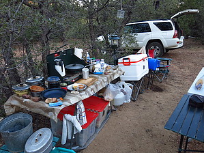
Vehicle "In-Car" Camping and/or Vehicle "Tent" Camping for 1-3 vehicles and/or 1-3 tents at 6255 feet elevation at a short, but secluded location off FR609; Available morning and afternoon shade/sun at this oaks and pines primitive Vehicle Campsite area;


This Vehicle Campsite location provides a good basecamp location for planned multi-day North and Northwest Sierra Ancha off-trail hike explorations and/or remote area Forest Road drives.


    Check out the Triplog.
    Leave No Trace and +Add a Triplog after your car camp trip to support this local community.
    WARNING! Hiking and outdoor related sports can be dangerous. Be responsible and prepare for the trip. Study the area you are entering and plan accordingly. Dress for the current and unexpected weather changes. Take plenty of water. Never go alone. Make an itinerary with your plan(s), route(s), destination(s) and expected return time. Give your itinerary to trusted family and/or friends.

     Permit $$
    None


     Directions
    or
     Road
    High Clearance possible when dry

    To car camp trip
    From the PHOENIX, AZ area:
    Hwy 60 West to Globe, AZ at Hwy 188--> Hwy 188 North to Hwy 288 North--> Hwy 288 North to FR609 Southwest/Left Turn (Hwy 288 North between McFadden Peak and Board Tree Saddle)--> Left Turn SW onto FR609--> FR609 for .40 miles to high clearance entrance, no signage, easy to miss, Right Turn NNE into Campsite access at Gps Coordinates 33.939703 -110.967902
    page created by Grasshopper on Dec 03 2018 3:29 pm
     90+° 8am - 6pm kills
    helpcorrectionissue

    end of page marker