Route Editor

| Guide | ♦ | 3 Triplogs | 0 Topics |
details | drive | no permit | forecast | map |
stats |
photos | triplogs | topics | location |
| 32 | 3 | 0 |
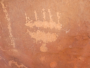
Meet the Dominguez' by Steph_and_Blake  This hike, located in both the Dominguez-Escalante National Conservation Area and Dominguez Canyon Wilderness Area, initially follows the Gunnison River, but then heads up Big Dominguez Canyon. With little elevation gain and a wide, smooth trail this is deemed a moderate-effort hike only because of its length. For some the main attractions are the petroglyphs and ruins, but there are a couple of swimming holes, remnants of ranching operations, and the beauty of the canyon itself to behold. If you're lucky, you might spot desert bighorn sheep. Warning Much of the hike is in a Wilderness area, so it is only open to those on foot or horseback. Dogs are to be kept on a leash. Also, part of the hike is between railroad tracks and canyon walls so be alert for an oncoming train.
From the main parking area, proceed down the road (south) to the smaller parking area (set up for boaters). From there head southeast to a maintained gravel/dirt road that parallels the railroad tracks. Here and there you'll get glimpses of the Gunnison and after a short distance the road leads you across the tracks. Eventually you'll come to and old bridge that is clearly signed for you NOT to use. Continue along the road to arrive at the newer bridge. Cross the river here and, if you're an angler, conduct recon on possible future fishing spots. Once across the bridge you'll be on the west side of the river. The trail is now sandy and still very easy to follow. Note the extensive irrigation system that was once used. A lot of work went into building it! Eventually the trail bends to the right and you come to a large BLM kiosk. Sign in, go through the gate, and step into the Dominguez Canyon Wilderness. You'll hear a small waterfall to your left that's worth checking out. Follow the wide, mostly smooth path and in about a half mile you'll come to a "Y". This is where Big Dominguez and Little Dominguez canyons meet. Take the right "arm" of the "Y" to go up Big Dominguez. In about a mile you'll come to a rock shelter built, or so the large inscription says, by M. A. Wooley on March 10 (18?) of 1901. Continue up Big Dominguez and keep an eye out for rock art and shelters. At about the 3.6-mile mark you'll come to what is called "Newspaper Rock", on your left. You'll know you're at the right boulder as there's a small, knee-high BLM sign advising you how to respect this archaeological site. Don't turn around just yet. A couple hundred feet further up the trail is another interesting boulder, on your right. It has rock writing on three of its sides. You might also spot some petroglyphs high up on the canyon wall so bring your binos. Return the way you came. Or, if you organized a shuttle, you could continue another 9+ miles to the upper end of Big Dominguez Canyon. Water Sources No springs were indicated on the map, but the Gunnison is always flowing and the Big Dominguez Creek is also probably a reliable stream. Note that there was plenty of evidence of cattle having been in the area, so treat the water appropriately. Camping There are campsites along the Gunnison for boaters. Camping is also allowed in Big Dominguez Canyon, but not for the first couple miles. For more clarification, check with the BLM website to determine where camping is/isn't allowed. Note This hike has been written up in the popular guidebook: Hiking Colorado's Western Slope and other descriptions as well as gps routes are easily found on the internet. As such, we felt it acceptable to submit a Guide here. Gate Policy: If a gate is closed upon arrival, leave it closed after you go through. If it is open, leave it open. Leaving a closed gate open may put cattle in danger. Closing an open gate may cut them off from water. Please be respectful, leave gates as found. The exception is signage on the gate directing you otherwise. Check out the Triplogs. Leave No Trace and +Add a Triplog after your hike to support this local community. | |||||||||||||||||||||||||||||||||||||||||||||||||||||||||||||||||||||||||||||||||||