Route Editor

| Guide | ♦ | 22 Triplogs | 0 Topics |
details | drive | permit | forecast | map |
stats |
photos | triplogs | topics | location |
| 6 | 22 | 0 |
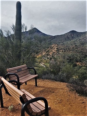
Butterfly Approved! by gad38  Overview OverviewNice, easy, short hike with a slightly elevated view of Cave Creek and the trail. This short side trail in the Spur Cross Conservation Area of Maricopa County Parks & Recreation is located at 44000 N. Spur Cross Road, Cave Creek, AZ 85331. Hike Start at the parking lot about 200 yards south of the Spur Cross Trailhead. Hike to the trailhead, pay your use fee at the entry and then hike out the main trail heading North.
Keep hiking on the wide trail until you reach the Mariposa Hill trail sign on the right side of the trail (one mile from the parking lot). Head up for a little less than a quarter of a mile to reach the top of the hill. There are benches to sit on while you look around and enjoy the panoramic views. Synopsis This is a very easy trail and pretty short too, but a nice warm-up or a side trip to longer hikes in the area for the more adventurous hiker. The trail is fully exposed to the sun with no shade, so it's great in Winter. In hotter times, you are better off to travel in areas that offer occasion shade - although the short distance of this hike may make this an unneeded caution. Translation Mariposa is the Spanish word for Butterfly. Check out the Triplogs. Leave No Trace and +Add a Triplog after your hike to support this local community. | |||||||||||||||||||||||||||||||||||||||||||||||||||||||||||||||||||||||||||||||||||||||||||||||||||||||||||||||||||||||||||||||||||||||||||||||||||||||||||||||||||||||||||||