Route Editor

| Guide | ♦ | 1 Triplog | 0 Topics |
details | drive | no permit | forecast | route |
stats |
photos | triplog | topics | location |
| 16 | 1 | 0 |
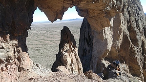
Thread the Eye of the Needle by Metalrunner  Eagletail Wilderness The Magnificent Natural Arch Loop My first entrance into the Eagletail Wilderness came around 1993 with my climbing partner and his wife. Our goal that day was to climb to the top of the mountain and stand foot on each of the summit feathers. I first learned about this backcountry climb when I accidentally stumble upon an old issue of Arizona Highways and read an article about the climb. I did my research, came up with a plan of action. Lisa, Don, and I were off to see if we could accomplish our goals. To gain the summit ridge, we had to rope up and ascend an easy 5th class pitch. From there, a stroll put us at the base of the summit feather, the most difficult to climb. Rated at 5.6, Don and I concurred a more realistic rating would be 5.8. Don led the single pitch to the summit, I followed, and we rappelled off. We then decided to save the Middle and South feathers for another day, seeing we were short on time. In climbing circles, the first ascent (FA) of Eagletail summit is known to have fallen into the hands of “Kachina Members” in 1976. First free ascent (FFA) came to Larry Trieber, Bruce Grubbs, and Chris Beal, a year later. Larry, Bruce, and Chris climbed the summit pinnacle using rope and protection placed in cracks, as safety in the event of a fall. Progress was made with hands and feet on edges, ledges, and hands, feet, or fingers inside cracks. The Kachina Members used protection, both for safety and to make upward progress.
In 2012 I turned my attention back to the Eagletail Wilderness, this time focusing on exploring the areas I had neglected. Steve, Ozzie, and I drove out to the north side of the wilderness and began walking due south. The goal was to get a closeup view of the feather pedestal and walk around the Labyrinth. Reconnaissance of this rock island would lead to further, more in-depth investigations into its center. The maps of the Eagletails disclose several “natural arches” but no indication as to their possible magnificence. Possible extra credit for us was to get up close to one or more of these landmarks on this day. From this day of exploration, this hike was born. Gateway to the Labyrinth From your car, look southwest and locate the feathers on top of Eagletail mountain. Follow the ridgeline left and into an indistinct saddle with two pinnacles. Everything left of these pinnacles is the Labyrinth. Between you and Eagletail mountain is a small, granite ridge about 1.5 miles away. Use the east end of this ridge as a landmark, as well as the two pinnacles. Head south and slightly west, passing the east end of the granite ridge, and head for the pinnacles. Stay in the flats, eventually passing around the two, pinnacles on their east and into the valley between the Eagletail feather pedestal and the Labyrinth. Head up this drainage and into High Point saddle at 33.3887 -113.3006. As you draw closer to the two pinnacles, the route becomes more obvious with great views of the rocks that create the Eagletail feather pedestal and Labyrinth. When the Labyrinth starts to dominate your eastern view, look for a fin of rock that anchors the labyrinth on its NE side, to the valley floor. This fin is where you’ll find the Magnificent Natural Arch (MNA). If not now, in a few more feet, you will notice The Fin has, near its top (south side) a smaller fin, and below is a prominent saddle, Fin Saddle. These are landmarks you will be using on your return. Getting Around the Labyrinth From High Point saddle, stay west of the drainage and work your way around to the south side of the small peak in front of you. Follow our route or make your own, and continue down into the valley to intersect with the Ben Avery trail. Follow this trail to the eastern trailhead and prepare to thread the needle, tie up loose ends and head home. We took our lunch break here, isolated and remote, not a sign of another human. Just minutes before we would depart, a truck slowly rolled towards us from the east and parked. Out popped a man, woman, two children, and a very tall greyhound with a plush sweater. I took one look at the man and had a feeling that I knew him. A few questions and answers later, we pieced together that we had met the previous summer in Colorado, where he was a campground host. My family and I had rolled into his full campground, and he helped us fill our water tank and offered advice on where we could camp. Head northeast and bite off the east end of the ridge that blocks your view to the north. On the north side of this ridge, walk northwest around the next ridge's tip and step into the large cirque. Facing NW, the ridge in front of you is the goal. On the east end of this ridge is The Fin and Fin Saddle, landmarks you viewed earlier in the day from the NW side of the Labyrinth. Head for Fin Saddle at 33.3887 -113.2802. As you approach, the smaller fin appears, and what might resemble a shadow is the larger of the three arches, The Magnificent Natural Arch. As we approached the drainage that empties Fin Saddle, we chose a line that I would describe as the MNA's direct fall line. We ascended a tongue of exposed bedrock, traversing right (NE) into a small drainage, past a large black chockstone, and straight up. Small Palo Verdes provide grip as the footing is loose and what isn’t loose is crappy, ready to crumble under pressure. Stay close together or out of each other’s fall line. The potential for rockfall is high. Thread the Eye of the Needle and Head Home Enjoy your time sitting in the saddle of the Magnificent Natural Arch, take in the view and consider a scramble up to Fin Saddle for the view to the west. Look up higher on the small fin, and you’ll see two, smaller arches. Climb through the MNA, threading the eye of the needle, and descend the slope, north. Not as bad as the ascent but not near as good as that valley floor you can see ahead. Again, stay close together or out of each other’s fall line. This side has/had several large boulders delicately perched and ready to create a disaster with little effort needed to set them off. Once on the valley floor, head north and a tad west, and if you are lucky or just perfect, you will intersect your outbound route right at your car. If you have a border collie like my Ozzie, as soon as you get close to your outbound line, he/she will push/pull you to that path and once again confirm a dog is not just a companion but can be a contributing member to your adventure. Check out the Official Route and Triplog. Leave No Trace and +Add a Triplog after your hike to support this local community. | |||||||||||||||||||||||||||||||||||||||||||||||||||||||||||||||||||||||||||||||||||||||||||||