username
X
password
register
for free!
help


Gray Fox Trail - White Tanks, AZ

Guide 22 Triplogs  0 Topics
  2.5 of 5  
Fav
Wish
0
details
drive
permit
forecast
route  
stats
photos
triplogs
topics
location
12 22 0
Statistics
tap row or icons for details
Difficulty 0.5 of 5
Route Finding 1 of 5
Distance One Way 0.9 miles
Trailhead Elevation 1,519 feet
Elevation Gain 85 feet
Accumulated Gain 85 feet
Avg Time One Way 20 minutes
Kokopelli Seeds 1.18
 Backpack No
feature photo
Photos Viewed All MineFollowing
Inaugural Calculation on Button Tap!
5  2025-05-23
White Tanks Competitive Track
Nightstalker
5  2025-02-11
White Tanks Comp Ford Loop
Nightstalker
4  2024-08-20
White Tanks Competitive Track
Nightstalker
2  2023-11-07
White Tank Mountains Big Loop
Nightstalker
3  2023-06-09
White Tank Tour
Nightstalker
7  2020-08-08 DarthStiller
5  2019-01-16 Hippy
Author
author avatar Guides 8
Routes 12
Photos 1,918
Trips 662 map ( 4,936 miles )
Age 39 Female Gender
Location Grand Canyon
Associated Areas
list map done
Phoenix Region
Historical Weather
Trailhead Forecast
Radar Map
Expand Map
Preferred Oct, Nov, Feb, Mar
Seasons   Early Autumn to Late Spring
Sun  6:06am - 6:52pm
Official Route & 1 Rt
 
0 Alternative


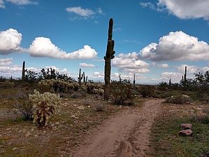
Unleash the Pedaler
by Hippy

 
Gray Fox Trail was created as a connector to the Competitive Loops area. It is a short multi-use trail inside White Tank Regional Park, at the North end of White Tank Mtn Road. This short trail starts at a nice big parking lot and can be connected to Ford Canyon Trail via Ironwood Trail for multiple shorter or longer loop options.


This would be a great trail for beginner mountain bikers to test their pedals on. Please be aware of hikers in both directions. Wildflowers are bound to be abundant in the spring months. Plenty of cholla and saguaros to ogle at along the way.
remove free decal offer
This would be an easy out and back for a family with young kids, a good alternative to the high traffic Waterfall Trail. Dogs are allowed on this trail but must be kept on a leash. Mountain Bikers are also allowed on this trail and are not required to be on a leash.

2019-01-17 Hippy
  • 2019 White Tank Trails Map
    area related
    2019 White Tank Trails Map
  • 2019 White Tank Mtns Closeup Map
    area related
    2019 White Tank Mtns Closeup Map


Check out the Official Route and Triplogs.
Leave No Trace and +Add a Triplog after your hike to support this local community.

One-Way Notice
This hike is listed as One-Way.

When hiking several trails on a single "hike", log it with a generic name that describes the hike. Then link the trails traveled, check out the example.
WARNING! Hiking and outdoor related sports can be dangerous. Be responsible and prepare for the trip. Study the area you are entering and plan accordingly. Dress for the current and unexpected weather changes. Take plenty of water. Never go alone. Make an itinerary with your plan(s), route(s), destination(s) and expected return time. Give your itinerary to trusted family and/or friends.

 Permit $$
Maricopa Regional Parks - 2024 [ fees ]

$7 per vehicle, $85 annual or trade your firstborn for the life pass

$2 walk, bike, or horse ride into the park

2024 [ hours ] - varies by park & season


 Directions
or
 Road
Paved - Car Okay

To hike
From Phoenix, AZ
Take I-10 west to the 303 North.
Take 303 North to west Northern Ave. Stay on Northern for 1 mile, turn right (north) onto Citrus. Stay on Citrus for 1 mile until you reach Olive.
Turn left (west) onto Olive Avenue.
Stay on Olive for 3 miles to reach White Tank Regional Park entrance gate.
Follow the main Park road (White Tank Mountain Road)to Gray Fox Trailhead
page created by Hippy on Jan 17 2019 2:59 pm
 90+° 8am - 6pm kills
helpcorrectionissue

end of page marker