username
X
password
register
for free!
help


Quarry Road Trail, CA

Guide 2 Triplogs  0 Topics
  2 of 5  
Fav
Wish
0
details
drive
no permit
forecast
map
stats
photos
triplogs
topics
location
8 2 0
Statistics
tap row or icons for details
Difficulty 1 of 5
Distance One Way 5.6 miles
Trailhead Elevation 674 feet
Elevation Gain 250 feet
Kokopelli Seeds 6.43
 Interest Historic, Seasonal Waterfall, Perennial Waterfall, Seasonal Creek & Perennial Creek
feature photo
Photos Viewed All MineFollowing
4  2010-06-13
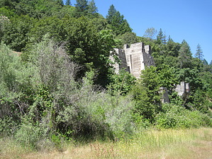
Mountain Quarries Railroad
AZLOT69
4  2010-06-13 AZLOT69
4  2009-06-20 AZLOT69
Author
author avatar Guides 16,843
Routes 17,472
Photos 24
Trips 1 map ( 6 miles )
Age 28 Male Gender
Location HAZ, TrailDEX
Associated Areas
list map done
Sierra Nevada Region
Historical Weather
Trailhead Forecast
Expand Map
Preferred Apr, May, Oct, Mar
Sun  5:36am - 6:29pm
0 Route
 
0 Alternative


remove free decal offer

  
Guide Needed
Publish Full Detail Guide


Use +Add above to share photos and triplogs
Overview: A flat wide trail where flumes once existed during the California gold rush. Beautiful views of the American canyon and American river.


    Check out the Triplogs.
    Leave No Trace and +Add a Triplog after your hike to support this local community.

    One-Way Notice
    This hike is listed as One-Way.

    When hiking several trails on a single "hike", log it with a generic name that describes the hike. Then link the trails traveled, check out the example.
    WARNING! Hiking and outdoor related sports can be dangerous. Be responsible and prepare for the trip. Study the area you are entering and plan accordingly. Dress for the current and unexpected weather changes. Take plenty of water. Never go alone. Make an itinerary with your plan(s), route(s), destination(s) and expected return time. Give your itinerary to trusted family and/or friends.

     Permit $$
    None


     Directions
    or
     Road
    Paved - Car Okay

    To hike
    Take Hwy 49 south from Auburn, Ca. turn right across the American River towards Cool. Turn left on a small dirt road ¼ mile south of the river crossing. Trailhead is beyond the parking area at a green gate.
    page created by AZLOT69 on Jun 24 2009 7:35 am
     90+° 8am - 6pm kills
    helpcorrectionissue

    end of page marker