Route Editor

| Guide | ♦ | 8 Triplogs | 1 Topic |
details | drive | no permit | forecast | map |
stats |
photos | triplogs | topic | location |
| 89 | 8 | 1 |
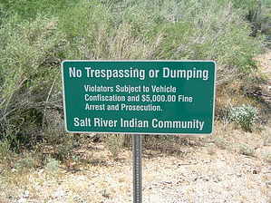
Five Thousand Dollar Climb by HAZ_Hikebot  Warning: It's illegal to hike this mountain without permission from the Salt River Pima-Maricopa Indian community. Violators are subject to vehicle confiscation, $5,000 fine, arrest and prosecution. Warning: It's illegal to hike this mountain without permission from the Salt River Pima-Maricopa Indian community. Violators are subject to vehicle confiscation, $5,000 fine, arrest and prosecution.Keep in mind this is a sovereign nation.
Check out the Triplogs. Note This is a more difficult hike. It would be unwise to attempt this without prior experience hiking. Leave No Trace and +Add a Triplog after your hike to support this local community. | |||||||||||||||||||||||||||||||||||||||||||||||||||||||||||||||||||||||