Stewart Mountain Dam - Horse Trails, AZ | HikeArizona
username
X
password
register
for free!
help


Stewart Mountain Dam - Horse Trails, AZ

Guide 3 Triplogs  0 Topics
  5 of 5 
Fav
Wish
0
details
drive
no permit
forecast
route  
stats
photos
triplogs
topics
location
22 3 0
Statistics
tap icons for details
Difficulty 1 of 5
Route Finding 2 of 5
Distance Multi-Loop 5.25 miles
Trailhead Elevation 1,446 feet
Elevation Gain 292 feet
Accumulated Gain 478 feet
Avg Time Round Trip 2-3 hours
Kokopelli Seeds 7.64
 Interest Perennial Creek
unreported if dogs are allowed
editedit > ops > dogs to adjust
feature photo
Photos Viewed All MineFollowing
Inaugural Calculation on Button Tap!
23  2022-01-01
Willow Springs-Stewart Mtn Dam Kayak and Hike
ddgrunning
10  2019-12-29
Stewart Dam Petroglyphs
CannondaleKid
22  2019-03-16 topohiker
Author
author avatar Guides 14
Routes 115
Photos 4,682
Trips 2,758 map ( 41,025 miles )
Age Male Gender
Location Scottsdale, AZ
Associated Areas
list map done
Phoenix Region
Historical Weather
Trailhead Forecast
Radar Map
Expand Map
Preferred Oct, Dec, Dec, Apr
Sun  6:33am - 6:36pm
Official Route
 
0 Alternative
 
 Water


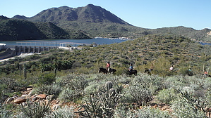
cross the salt and over the hills
by topohiker

 
There are a couple of trails east of the Stewart Mountain Dam on a fat peninsula. The Saguaro Lake Guest Ranch offers horse rides on the trails. The views are very spectacular. You get views of the dam, Butcher Jones trail, Saguaro Del Norte recreation site, Saguaro Lake, four peaks, and the Salt River. To access the trails you need to cross the Salt River.


WARNING
Crossing the Salt River can be dangerous or deadly if you cross when there is too much water flow.

I waited until the water release from the Steward Mountain dam was 10 CFS. The water was pretty much almost still and about one foot deep. With the water flow so low, there was a quarter-inch of moss on all the rocks which made them slick. I took my time crossing so I wouldn’t twist an ankle or slip.


There are two loops and a spur trail off of the upper loop. The upper loop offers views of the dam and the lake. There are also three survey discs along the upper loop. The spur trail takes you to a high point and drops down into by an old fence and has a downstream view of the Salt River. The lower loop is not that exciting. It’s on the desert floor and has some views of the desert plants. As of this writing, it had tall green grass.

Once you’re on the horse trail, follow it to a split. Turn to the left for the upper loop or right for the lower loop. I took the upper loop to the spur trail and then took the lower loop.

Check out the Official Route and Triplogs.

Leave No Trace and +Add a Triplog after your hike to support this local community.

2019-03-23 topohiker
    WARNING! Hiking and outdoor related sports can be dangerous. Be responsible and prepare for the trip. Study the area you are entering and plan accordingly. Dress for the current and unexpected weather changes. Take plenty of water. Never go alone. Make an itinerary with your plan(s), route(s), destination(s) and expected return time. Give your itinerary to trusted family and/or friends.

     Permit $$
    None


     Directions
    or
    or
     Road
    Paved - Car Okay

    To Stewart Mountain Dam Trailhead
    Access - Private Property
    Saguaro Lake Ranch might allow you to park & hike for a $15 fee as the Official Route suggests. Check in at the ranch guest house to obtain permission.

    Bush Highway Northeast of Usery, just past milepost 31 turn right on Stewart Mountain Dam Road. This leads to Saguaro Lake Ranch. Proceed past the ranch towards the fenced in gated access to the Dam. There is an off road turn around at the end of the road on the left. There is room for a few cars to park here. Pay attention to warning signs and do not block gate access.

    Access - Water Users Recreation Area
    Guaranteed legal if you get a Tonto Pass in advance. This adds 0.4 miles walking along the highway each way. Potentially unsafe by nature, virtually guaranteed to be undesirable.

    Access - Park Along Highway
    HAZ does not recommend such without consulting the law. That said it might be an option if...
    - you are NOT near a fire hydrant
    - NOT on a curve
    - VISIBLE from 150 feet in both directions
    - parked in the DIRECTION of flow
    - OFF the highway on a natural dirt apron
    - do NOT kill even a nuisance weed exiting & merging
    - 50 feet away from other stationary vehicles

    From PHX (I-10 & AZ-51) 41 min (36.3 miles)
    From TUC (Jct 1-10 & Grant) 2 h 1 min (125 miles)
    From FLG (Jct I-17 & I-40) 2 h 36 min (170 miles)
    page created by topohiker on Mar 23 2019 12:59 am
    helpcorrectionissue

    end of page marker