Route Editor

| Guide | ♦ | 1 Triplog | 1 Topic |
details | drive | no permit | forecast | route |
stats |
photos | triplog | topic | location |
| 0 | 1 | 1 |
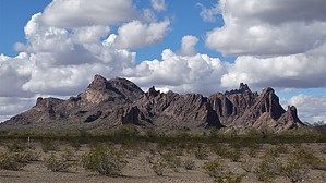
Labyrinth Optional by Barrett   Overview OverviewCreated in 1990, the 100,600 acre Eagletail Mountains Wilderness is only about an hour west of Phoenix, but offers both solitude and adventure to those inclined. Courthouse Rock and Eagletail Peak get most of the attention, but some of the coolest terrain can be found on a bag of Peak 2681'. Hike From the Eagletail Mountains Wilderness Trailhead 2681' and its approach is pretty straightforward if you want to go up the easy way. Make a beeline for the saddle between you and the summit, the rounded prominence on the left. Reviewing the photosets from my trip should help familiarize yourself with the route, in addition to GPS info.
The next goal is another saddle, this one just to the left of the summit. This part is relatively steep and off-camber but only lasts a few hundred yards before you level out, and the rock becomes cleaner. Just keep heading up, and soon you'll be among several "high points," one of which will have a cairn with a summit register containing only four names. The views of Eagletail Peak are postcard-perfect, and you'll get your first real view of "The Labyrinth," the wild hidden canyon to the north that cuts between the two halves of 2681'. From here, you can head down the way you came, or dial up the intensity a few notches and head down into the labyrinth. The first stretch is just moderately steep and loose, followed by the arrival of various drainages that, for me, ended in pour-offs and dead ends. The cleaned-up GPS route can guide you through this, but it gets both really steep and, at times, really brushy. Thorns are not too nasty - but long pants, sleeves, gloves, hat, and eye protection come in handy in plowing through the dense growth. This is not a route for those new to off-trail hiking. Soon it will begin to level out, and you'll reach the main drainage. This varies between brushy and boulders large enough to go under, making for some delightful travel. Enjoy the views on your right of the massive walls of aphyric rhyolite breccia - I couldn't get "In the Court of the Crimson King" out of my head. Majestic stuff. Upon exiting the drainage, head clockwise and follow the level ground around the peak back to the trailhead. Variations You could also choose to ascend via the canyon, or maybe throw in a visit to the fantastic arches on the eastern side while you're at it. It's not a very big mountain, but its geology and wild hidden canyon make it every bit as cool as it's more famous neighbors. Warning This is an entirely off-trail hike over a peak that sees very little traffic. The north canyon, in particular, is quite rugged and isolated and should not be attempted if there is any chance of rain. Check out the Official Route and Triplog. Leave No Trace and +Add a Triplog after your hike to support this local community. | |||||||||||||||||||||||||||||||||||||||||||||||||||||||||||||||||||||||||||||||||||||||||