 Route Editor

| Guide | ♦ | 11 Triplogs | 0 Topics |
details | drive | no permit | forecast | 🔥 route |
stats |
photos | triplogs | topics | location |
| 186 | 11 | 0 |
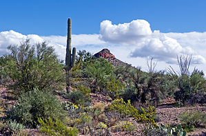
Sandy Canyon bypass by markthurman53  Overview OverviewThis Trail follows along the upper portion of Willow Springs Canyon from The Willow Springs Canyon Trailhead along the Apache Highway to Willow Springs Canyon just north of Willow Springs Basin. While this trail follows Willow Spring Creek, the difference between this and The Willow Springs Canyon Trail is that this trail follows just to the east along the hills, avoiding the wash. This trail allows access to Bagley Tank without the wash trek. It is longer and does have a lot of ups and downs as it crosses over multiple streams that are coming down from the hills to the east. There are good views over Willow Springs Canyon since it is higher up. Not a well-defined trail but easy enough to follow appears to be used mainly by horses. This trail is listed as the Lost Souls Trail on one mountain bike website, but that name wasn’t very descriptive, and I chose a more descriptive name. The Route posted is an actual GPS track up to the Bagley Tank Jeep Trail, and from there to Willow Springs Canyon, it is a track created by tracing the trail. Hike This trail starts at the Willow Springs Canyon Trailhead along the Apache Highway near Mile Post 204. There is plenty of parking to the north of the road. This trail starts about 20 feet from the gate at the parking lot and departs from the jeep trail in a northeasterly direction. Look closely, it is easy to miss. While the trail starts faintly, it becomes easier to follow the rest of the way. For the first mile, the trail parallels the Willow Spring Canyon Trail, which is just below. It will cross over three small streams in this first mile. Some of the descents into these creeks are pretty steep, which I wondered how horses fair on this. Overall, these descents and assents are short and don’t create much of an issue. After the first mile, the trail departs more from the Willow Springs Canyon below as Willow Springs Canyon heads in a more westerly direction. The trail continues in a northerly direction crossing three more streams as it heads over to the east side of an unnamed hill. Not sure why this trail chose to go on the east side of this hill, but it does. There is a bit of uphill as you approach the east side of the hill and a descent as you head over to Bagley Tank Jeep Trail. Once at the Bagley Tank Jeep Trail, head north on the road into the creek bed (about 50 yards) and locate the trail heading west. This is where I lost the trail because I didn’t have a GPS route and didn’t know the trail headed up the jeep trail. From Google Earth, this trail is visible, and I created the route from that. Trust me; it’s there.
Gate Policy: If a gate is closed upon arrival, leave it closed after you go through. If it is open, leave it open. Leaving a closed gate open may put cattle in danger. Closing an open gate may cut them off from water. Please be respectful, leave gates as found. The exception is signage on the gate directing you otherwise. Check out the Official Route and Triplogs. Leave No Trace and +Add a Triplog after your hike to support this local community. One-Way Notice This hike is listed as One-Way. When hiking several trails on a single "hike", log it with a generic name that describes the hike. Then link the trails traveled, check out the example. | |||||||||||||||||||||||||||||||||||||||||||||||||||||||||||||||||||||||||||||||||||||||||||||||||||||||||||||||||||||||||||||||||||||||||||||||||||||||||||||||||||||||||||||||||||||||||||


