Route Editor

| Guide | ♦ | 1 Triplog | 0 Topics |
details | drive | permit | forecast | map |
stats |
photos | triplog | topics | location |
| 16 | 1 | 0 |
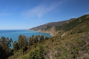
The Big in Big Sur by JimmyLyding  This area sees a high level of use, and is probably the busiest part of the Ventana Wilderness. All visitors must practice leave no trace ethics. Note that the Vicente Flat Trail runs from the Cone Peak Road which is above Vicente Camp, and not generally part of this description.
The trail climbs relentlessly uphill for 2.7 miles and 1600' to Espinosa Camp before turning north-northeast high above Hare Creek to follow the canyon slightly uphill through intermittent redwood groves that are remarkable only because of their southerly location and high elevation. Enjoy the views of 5100' Cone Peak through small openings, and dream of the day you can crush it in a day. This hike eventually gets to Vicente Camp deep in a redwood near the head of Hare Canyon. This appears to be an extremely popular place based on the number of tents I saw there on a Saturday afternoon. I am sure that I will be back here soon. The first triplog for this hike shows mileage between Vicente Camp and Cone Peak Road. The Vicente Flat Trail heads up the little side canyon to the northeast instead of the northwest no matter what the facts on the ground indicate. The first mile up has 500' of elevation gain, and goes through a nice wild redwood forest. Check out the Triplog. Leave No Trace and +Add a Triplog after your hike to support this local community. | ||||||||||||||||||||||||||||||||||||||||||||||||||||||||||||||||||||||||||||||||||||||||||||||