Route Editor

| Guide | ♦ | 5 Triplogs | 0 Topics |
details | drive | permit | forecast | route |
stats |
photos | triplogs | topics | location |
| 66 | 5 | 0 |
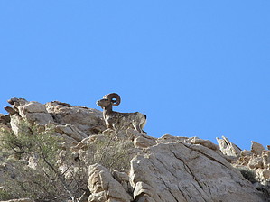
Unobstructed views to Mexico by Jim   In the far southwest corner of Arizona the Tinajas Altas Range are as scenic as much as they are isolated. Many miles of travel across sandy roads are required to access the high point of the range. You probably won't see anyone else out here, but someone might see you. Border Patrol and illegal crossers frequent the area, though they probably won't head up to the summit. In the far southwest corner of Arizona the Tinajas Altas Range are as scenic as much as they are isolated. Many miles of travel across sandy roads are required to access the high point of the range. You probably won't see anyone else out here, but someone might see you. Border Patrol and illegal crossers frequent the area, though they probably won't head up to the summit.Located 1.3 to 1.4 miles of travel on the dirt road from the intersection of A16B, the trailhead sits just east of the canyon used to access the drainage leading to the summit. If in doubt, the large slabs or dry falls located near the entrance are visible from the trailhead.
Follow the main drainage past where it turns northwest, and then west again. Once side drainages running SW from the main drainage appear, more or less take your pick and head up one of them to the ridge to your south. On the ridge, you can look south and across at Tinajas Altas Peak. Locate the large gully on the NE face that seems to head up to the back of the summit. There isn't much green in it, and there is a spire on the left side of it when viewed from the ridge. Walk the ridge to a small saddle and then head south across to the base of the peak and the gully. The gully is the last of a few choices to the south and requires a short scramble to enter at its base. There is a shallow cave here, which had an old Casio watch in it. Who knows, maybe that will be there in the future? Above the scramble section used to enter the last gully, there is more steep hiking to the last section near the summit. On the east face, there is a short ramp that requires some scrambling to gain the summit. It is fairly exposed up here, so it seems harder than it is. Last, the rock is generally good, but I had some holds break off in my hand. It is probably still just class 3, not 4, but it may feel like 3+. Enjoy your summit time, and descend safely the way you came. Check out the Official Route and Triplogs. Note This is a moderately difficult hike. Leave No Trace and +Add a Triplog after your hike to support this local community. | |||||||||||||||||||||||||||||||||||||||||||||||||||||||||||||||||||||||||||||||||||||